Joseph Mack, 2001, edited for FAQ by R N Caffin
The full version of this trip report may be found here. It was a 6 day hiking trip in Colorado, and the report was targeted to members of the Sydney University Bushwalking Club (SUBW). This summary has been edited down to give some idea of what walking at this sort of altitude is like. We have nothing this high in Australia, but many will recognise the effects from their own trips overseas.
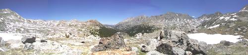
Holy Cross peak (14,006') is in mid distance (60% across image). The "Cross" is on the other side of the ridgeline. The two ridgelines on the left and the right of the image, are approximately parallel and facing the direction of the center of the photo. In this panorama, the ridgelines appear to run across the image.
Introduction
This hike was with an American friend, Steve. Like all trips in USA, where few people live near a wilderness, this is an epic, requiring multiple plane connections, taking all your food, and ordering maps over the internet. There being nowhere local with similar conditions (altitude) that I could train or test myself, I would be doing the trip cold. With little experience in cold and altitude on my part, this trip was possible only because Steve understood the conditions in Colorado, the altitude, animals, snow, weather... Steve drove 9hrs from Omaha to pick me up at Denver airport. We drove another 3hrs to spend the night in Eagle CO, and then the next morning we drove over a 10,000' pass to reach the trailhead.
Note re distances and heights
This report uses Imperial units (and even gets them wrong). These units are still used only in USA, Myanmar (Burma) and Liberia. The US has convinced the world to use feet/miles for altitude/distances for commercial airliners. Presumably it's safer to teach the rest of the world American units, than to teach metric units to Americans. The American units are confusing even to Americans, who turned the Mars Climate Orbiter into a Mars lander. A T-shirt celebrating the Mars landing had "Mars: hit the planet and win a prize. Remember 1 mile = 1.6km".
Preparations
Steve warned me to bring lots of sunblock - my skin would blister without it, that it would be like an oven during the day and near or below freezing at night. (At 4000m, only 60% of the UV is being filtered out.) He warned me that the effects of altitude were cruel at our age and it would take most or all of the trip to acclimate. (On my return, from the internet, I found that it takes most people several weeks to acclimate.)
The volleys that I've been bringing back from Sydney for the last 3yrs give me blisters easily. I've never needed to break in volleys before, but this process takes several weeks now. Since I hadn't done any long trips (cold, at altitude or otherwise) for 20yrs, I increased the load for my standard lunchtime walk from 30lb to 45lb, when even my broken-in volleys gave me blisters again. Steve's list includes insoles, something I don't think about, but important enough to Steve for a successful trip, that they get an entry. I bought every kind of insole at the local hiking store and the local athletic footwear store and tried them all out a day at a time, till I found one that fixed the problem. The ones that worked were smooth and shiney, letting my sox slip over them. At Steve's suggestion I switched from cotton soxs to smooth polypropylene sox, clearing up 3yrs of blister problems in one go.
Plateau Geography
Colorado is in the uplifted western 1/3 of USA, with valley floors at 5-8,000'. From maps of the world, this region appears to be the largest elevated area in the world. Here olympic athletes train, where they can sleep high (at 10,000') and drive to a nearby town where they can train low (a few 1000'). The surface features of this elevated area are varied. The western end (Nevada), is basin and range block faulting. The eastern end of the plateau meets the jagged peaks of randomly tilted metamorphic Rockies, which rise to 14,000'+. In the north, the large flat valleys and salt lakes of Utah are surrounded by sedimentary plateaux interrupted by the occassional metamorphosed mountain or inactive volcano. In the south are the mountains of New Mexico that Robert Oppenheimer loved, and where he moved the WWII atom bomb project (Los Alamos).
In the middle is the Colorado-Utah plateau. This is a sedimentary basin (like Sydney's) many 100's miles in diameter with near horizontal strata. The basin is best known for where it has been cut deeply and rapidly by the Colorado R., forming the Grand Canyon, a sight so grand, that I recommend you see or hike through at least once in your life.
The whole elevated area is arid, and cold in winter. The area is desert being in the lee of the prevailing winds from the west which pass over the (Californian) Sierras. As you cross the Sierras from the west to the east, green forests turn into Nevada desert in a matter of miles. You can stand on the ridge line or at a pass and look on green vegetated valleys to the west and brown arid valleys to the east. As the air crosses the 500 miles of the Colorado-Utah plateau it picks up moisture again (although no-one has told me from where, it's hard to imagine it's from the desert below) and rainfall increases gradually as you reach the Rockies. Then as you cross to the eastern, lee side of the Rockies, the rainfall drops again. Although desert or near desert, there is plenty of snow in winter. Being on the western side of the continental divide (the Rockies), the water from the plateau mostly flows to the Colorado R. (with some to the Rio Grande). The water which falls on the lee (eastern) side of the Rockies flows to the Mississippi R. The main primary industry of the plateau area is cattle ranging and more recently skiing and people like Steve and I (tourists). There is not enough water to grow food commercially in most areas, although the Native Americans lived on corn grown in the few watered valleys, using precise observations of the winter solstice to plant their crops. With only 120-130 frost free days and because of the altitude, there is little time to spare
Getting there, and starting
Eagle, where we stayed at 6,600' the first night, is on the eastern edge of the Colorado-Utah Plateau. The cliff faces instead of being flat with cleavage planes like in Sydney, are either rows of columns or pillars (common in the Canyonlands) looking like totem poles, or rows of totem poles waiting to be sculpted out. The points on the ends of the cliffs all have miniature Three Sisters type rock formations. A few miles to the east of Eagle, the rocks change to the convoluted metamorphosed Rockies. This is where we went to hike. There on the hike, I saw bands of rock folded into an "S" that fitted into a square box 1' across.
The real problem hiking would turn out not to be my joints, but the altitude. My last trip at altitude was about 20yrs ago. Back then, as long as I spent a night at 8,000' I was OK to go higher the next day. The alternative to spending a night at 8,000' was terrible headaches. On my last trip at altitude, I scrambled to the top of Mt Ritter at 14,000'+, the highest peak in the central Sierras. I was OK till 14,000', when I was only a few 100' from the top on a smoothly convex pile of broken rock. From there, at sea level, attaining the peak would have been trivial, but here I needed 3 breaths for every step. It took forever to finish the final walk to the top. Once I got down below 14,000', I was back to operating as if I was at sea level level again. I was hoping it would be the same this time, but with 20yrs of accumulated decrepitude, I knew this would be a new toss of the dice.
Steve picked me up at Denver airport. Denver airport was at 5,000' (the "mile high" airport). To reassure myself, I looked for signs of altitude as we drove out of Denver into the mountains, but sitting in Steve's car I was unlikely to find any and didn't. Last time I was in Denver, 25yrs ago, the air was clear, but now with all the new arrivals, the air pollution in Denver reduces the visibility to only a few miles, all due to car exhaust and the low rainfall. It looked just like LA to me. The mountains a few miles away were seen only in silhouette.
Arriving in Eagle at 6,600', 150miles west of Denver, the air was clear and the sky a deep blue. However just walking around required breathing as if I was climbing a steady 30deg slope. For heaven's sake I thought, 6,600' is nothing: the air pressure in a jet airliner (equiv to 8,000') is lower than at Eagle. I felt quite light headed, like I'd had a beer on an empty stomach. Expecting a splitting headache the next morning, I passed on the beer with dinner, thinking it would put me at an effective altitude of 12,000'. I hoped by not challenging the gods of altitude headaches, they wouldn't notice my arrival.
One of the first things you notice in Colorado, is the simultaneous aridity and large amounts of water in the many rivers. The humidity was 10-14% by my personal portable sling psychrometer. (The humidity was 5% at Blue Gum on Xmas day 2001 during the bushfires). The soil was dry with mostly sagebrush and some cedars and pinion pine. Mostly the dirt was just dirt, there being no other ground cover. Right next to the bare dirt could be a rushing clear river with nothing growing in the river - all the rocks were clean. Large amounts of water rush and tumble through the rivers, any one of which has more water than all of the rivers around Sydney combined. The next morning, in Eagle, I awoke with a clear head. The gods of altitude headaches had not found me and I optimistically hoped for few altitude problems.
The trip, and altitude
The trailhead was about 2hrs away along a dirt road, over a pass at 10,000'. We quickly left the dry sagebrush valley and entered trees at the cooler and wetter elevation. Up to about 8,000', many of the creeks had beaver dams. Beavers have only recently returned to the area, having been trapped, mostly by leg-hold devices, for their pelts. A river with a beaver dam every mile or so will delay the spring run-off into the whole summer, keeping the rivers downstream flowing all year. The beaver ponds allow plants and fish to grow, and provide food for birds and animals and nesting spots for birds. Above 8,000' there were no more beaver dams. Beavers can go to 10,000' here, but haven't repopulated higher altitudes yet. Presumably beavers will stop at high enough altitude, where the ponds behind their dams freeze solid in winter.
There were only 2 species of trees visible from the car, blue spruce (a pine) and aspen (a broadleafed dicot). Looking at the pattern of trees on the sides of the mountains across the valley opposite you, these trees mutually excluded each other. The aspens are light green, while the blue spruce are dark green. The aspen leaves flutter in the slightest breeze, giving rise to the name "quaking aspen". The demarkation line between they two species was sharp and you never saw one tree in a stand of the others. The low diversity of trees is normal in cold climates like North America. There are supposed to be more species of plants in some small area (1 acre?) of the Amazon than in the whole of North America.
Once you start walking you see the vegetation on the ground too. Along the river beds and where it's wet, the lower storey equivalent of the Sydney lower storey scrub is a willow, a bush about 1' high in most places, but occasionally head height. Otherwise away from the water, there's no understorey.
The trailhead was at 9,800'. It was in the treeline, so we would be walking in shade, but standing on the road, the sky was a cloudless deep blue and the sun dazzling. I put on sunblock and looked at the maps with Steve. At home I'd formulated several side trips to cover as much territory as possible (provided of course that altitude wasn't a problem). There were several nice looking long traverses at 14,000' but I didn't fancy being caught in the open at 14,000' (there being no other type of ground at that altitude) if a storm/snow brewed up. I just didn't have much experience in this environment and would rather have a low excitement trip for a first effort here. It was only 12noon. Being at 40 deg latitude, 2 weeks before the summer solstice, we had over 16hrs of daylight and with daylight savings we still had 9 hrs of it left. We could do a good day's hike in the remaining time, even starting at noon.
Steve pointed on the map to the proposed Camp I; a lake a 2 miles away. What the hell was I going to do with the rest of the daylight with tonight's campsite just up the valley? I told Steve I'd be there in an hour, tops. Steve cocked an eyebrow "Is that so? On your first day at 10,000', you'll be happy just to get there."
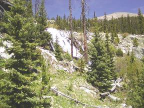
We ascended a parabolic valley through trees beside a tumbling river. There being no understory, the ground was fairly open, so a trail wasn't neccessary. However the river passed through waterfalls and overhung restrictions which were difficult to navigate (the cleavage planes were about 20deg from the vertical). The river was wider than a jump in most places. You had to pick your place to cross. Having no interest in tangling with rushing water and large rocks, we stayed on the trail as much as possible. From the footprints on the trail, we were the first humans to use it since the spring thaw, but plenty of elk had passed this way. Even though in the sun it was hot, in the shade it was cold, and shortly we came across our first patches of snow.
We arrived at the proposed campsite at 2:30pm. I'd done it in relays of 20steps, punctuated by pauses of heavy breathing. I thought I'd done OK, and was about to exhort Steve to press on, when I sat down and found I didn't want to get up. I had walked no more than my usual lunch time walk but I was exhausted and even sitting down, couldn't stop hard breathing. I gave my "You were right and I was wrong" obligation to Steve.
Rather than being determined by the air, the temperature was determined by the combination of heat from the direct sun and the cooling of the intermittant daytime stiff breeze. If I was in the sun I was hot, if in the shade I was cold. I started wondering how the austronauts had regulated their temperature on spacewalks or on the moon - did they have to keep turning in front of the sun? If the daytime stiff breeze was blowing, the sun and breeze cancelled each other and I was at a reasonable temperature, but you had to keep up with the sunblock. In the shade you were cold, or with the breeze - even colder.
The ground was as wet, as I expected, but not muddy. From hiking in Tasmania and the California Sierras, I associate alpine with mud, camping on rocks or mud and having to tie your tent ropes to rocks because of the lack of soil. Here instead, the top 3" of ground cover was spongy moss. In some places the moss was dry and in other places, had water slowly running through it from uphill melting snow. Treading on the wet moss squished out clear water rather than mud. With the low humidity, there was no need to avoid the wet spots - your feet were dry in minutes and without the mud, your feet stayed clean. Below the moss was another 3" of nice soil. If you were anywhere with ground cover (i.e. not in a field of broken rocks), you had 6" of nice clean ground cover to grip your tent pegs. There were plenty of dry soft spongy place for your tent (no sleeping on rocks here). It looked like you could have any amount of rain and still be sleeping on dry ground.
With the high mountains on both sides, the time of direct sunlight was reduced from 16 to about 10 hrs. After sunset behind the ridge, the sky would still be daylight blue, but the air temp would crash to near freezing, and there still would be 3 hrs left before the sky became dark. I put up the tent, and crawled in, breathing hard to recover from the exertion of this herculean effort, and lay down while I figured out what to do next. Just lying down, I was breathing as though I was walking uphill with a pack. What to do? I couldn't lay in the tent for 14 hrs like I was on a winter trip - it was still daylight outside. I hoped to get acclimatised and be over this phase shortly, certainly in time to enjoy most of the trip. My idea of a good hike was covering the most distance in the time available. At this rate I would be walking about 1/4 of the time and for the rest of it, sitting down freezing cold and puffing.
Steve has a different approach to trips where you aren't acclimatised to the altitude. Steve grew up hiking and camping, initially with horses the way it would have been done here 100yrs earlier. He comes for the fishing. He also carries a pack 20lbs heavier than I do, with fishing rods and clothes for the cold, to help him with the idle time, when like it or not, you can't do a whole lot even if you want to.
The lake was about 6-10' deep and clear enough to see the bottom. I don't often see to the bottom of water 6' deep. (Steve says it's 40' deep in the middle out where I couldn't see.) In the lake's tributaries, trout, some 20" long, swam. The water in the tumbling tributaries was crystal clear. I couldn't imagine there being enough organic material for the fish to live on. Apparently they live on surface insects, some aquatic life, worms, and stone fly larvae. I didn't see enough of them to keep a single fish alive, much less all the fish I saw in front of me. The river looked like a wet desert to me.
The downwind parts of the lake were covered in a lime green powder, blue spruce pollen according to Steve. Back in North Carolina, for a few weeks in spring the local loblolly pines fill the air with green pollen so thick that on a still day, the air is visibly green, if you have a piece of straight road long enough (about 1 mile) to look along. Cars parked overnight are covered with green powder and many people are incapacitated by their allergies to the pollen. I've started getting the allergies in the last few years. You feel like you have a cold and your eyes and nose run all day. Mardee has allergies from the beginning of spring till the end of summer and for her exercise, goes swimming or winter hiking (anything but outdoors in warm weather).
I raised myself from my hypoxic lethargy, to wash before the sun set behind the mountain. I knew if I was cold now, I'd be even colder with the sun behind the mountain. I was quite looking forward to washing in a clean mountain stream, where thanks to the low humidity, I'd be dry in record time. I took off my volleys and stepped into what I quickly found was melted snow. It was a truly invigorating wash. With the low humidity, no rain and plenty of water for washing, I stayed clean and dry the whole walk. (I don't remember washing much in Tasmania. There, being wet 24x7, staying dry was my major interest.)
To make drinkable water, Steve had filter pump. The river water always has to be assumed to have giardia in it, presumably from the beavers if nothing else. Whether the beavers get the giardia from us or we get it from them I don't know . I realised that I shouldn't dip my billy in the river anymore and risk contaminating my food. I washed the billy with filtered water, and heated the billy dry on the stove to kill any giardia cysts. From 1951 through 1990 Steve drank straight from the creeks and streams with never a concern, as had his parents, grandparents and great grandparents before him. There weren't as many beaver back then (even though they were always there). It's the people camping beside, washing, and using the streams as a toilet that prompted the filter (human viruses are going to do you a lot more damage than anything a beaver carries). I remember the days when you could drink from the Kowmung (a large river in the Blue Mts west of Sydney) too, but now I hear people are getting sick from it.
You cook on a propane/butane stove. The fuel, along with the water filter and all the other paraphernalia for the cold, add up weight-wise. Campfires are eschewed here. We were hiking during a fire ban, but in any case, no-one makes fires. Downed wood in the Sierras (California) was always wet and rotten and there was no wood to burn, so I was already used to hiking without a fire (but didn't really enjoy it). Here downed wood was bone dry and there was wood to burn - it was everywhere. I couldn't understand how 300yrs of wood fuel could accumulate without a major conflagration or two on the way. There was plenty of wood if you wanted it, but no-one wants it. It seems to be a matter of leaving nothing but footsteps and a fire-ring is regarded as gauche.
There were rodents everywhere, a few pikas (they sit on rocks and call out "pip!") but mainly chipmonks. (On the road out, Steve pointed out the many gophers running across the road, scurrying to their holes at our approach.) Steve slung a rope between two trees and we hung our food on the rope. Steve was expecting varmints (energetic mammals, rodents usually, that can smell food through closed containers and will chew straight through your pack in seconds). You either have your food in your pack beside you, in your hands or in a tree. The local varmints seemed quite friendly and harmless to me. They didn't appear to be the big problem Steve made them out to be, but having already been wrong about other things that day, I hung my food up next to Steve's.
For dinner not only did I have no energy to prepare it, I had no appetite. My body thought I was climbing a hill with a pack, not a time I normally eat. I thought of food or eating it was repulsive and I almost wished the varmints would take it off me, to save me thinking about it for the rest of the trip. I'd brought a carefully weighed amount of food for each meal and I either had to eat it, carry it or chuck it. I can eat anytime normally if I'm at sea level, but I now I was a most reluctant dinner.
Leaving only footsteps is all well and good, but once the sun goes down behind the mountain, if you don't have a fire, and you didn't bring parkas and thermal pants, then you have to get into your tent. None of this sitting around the campfire drinking tea business. I'd opted for the lightest pack I could, to optimise the chances of my body lasting the week, and so after dinner, retired to my tent with the sky the color of mid-afternoon. I just beat the mosquitoes for the evening (they're only out at sunrise/set). Steve who was 20lbs better equipped than I, got into his cold outfit and paraded around gleefully calling out the fauna I was missing (e.g. bats, which I like). He wasn't enjoying the mosquitoes, but expected that the bats would get them. I releaved him of his delusion by telling him that bats don't eat mosquitoes (they're too small to be picked up by the sonar and bats don't eat mosquitoes in test situations).
I now had about 3hrs to dark. Inside the tent it was probably 5-10C, but with enough clothes and sleeping bag to take me well below freezing anywhere else, I was still freezing cold, I lay there wondering what it was like to spend a night at camp IX on Mt Everest. There was only so much philosophy I could handle and soon enough I went to sleep. Next morning I awoke nauseated, with a headache and no energy. Clearly by my breathing I had not accumulated a whole lot of altitude adaption overnight. No wonder asthmatics get distressed when they can't breathe. Not only that, my eyes were stinging and watering - I was allergic to the Blue Spruce pollen. It hadn't occured to me to bring allergy medication (or ask Steve, he had some in his kit and which I didn't know about till after my return). I don't normally eat breakfast, but on a hike I thought I should. I ate 250g of muesli, which was no fun at all. Under the circumstances it was the most difficult thing I did all day (dinner was the next most difficult). Dehydration is supposed to be a problem at altitude. I wasn't at all thirsty and just decided that if I peed occassionally and it was a suitable colour, I was probably doing OK. Steve decided that we should take an altitude adaption hike, upto our next campsite and back, without packs. In the afternoon we would fish.
With Steve and I both having PhDs in biochemistry, I tried to figure out the biochemistry of the altitude problem. I wondered what I could do to make any subsequent trip easier. At least understanding it would seem a step ahead of the impotence I felt on having it. I didn't find out much about the problem till I returned home and started looking on the internet. The real problem I was having (headaches, nausea) turned out to be mild oedema. I don't remember breathing hard at this altitude.
We were walking mostly in snow and the trail, if ever you found it, quickly disappeared beneath drifts. The light was blinding and I had to squint. I now found the only thing that Steve had forgotten to mention in his list - sunglasses. Steve always carries clip-on sunglasses and doesn't regard them as part of his hiking equipment. I was staggering around in the blinding snow, while Steve was wearing jet black clip-ons that looked like arc-welding glasses.
I still was feeling the effects of altitude, and within sight of the pass at 11,800', the nausea was steadily increasing. The breakfast coffee and most of last night's dinner were still in my stomach. I told Steve that I'd had a headache since the first morning and I wasn't feeling my usual cheerfull self at the moment. I tried ignoring the symptoms, till it dawned on me that the waves rushing through my body were familiar symptoms from another area of my life. They signalled the imminent arrival of my first chunder in Colorado. Picking a convenient spot (75' from water), I did the two finger salute and disgorged the lot.
Having just a few minutes before found out about my multiday headache, Steve was most concerned at this new development. For what reason I could not imagine, as I now felt better than I had for days. Steve was worried that I was developing cerebral oedema, one of the outcomes of altitude sickness, and that I would shortly go into convulsions. (Cerebral odema can be fatal and you only have a day or so warning of its onset to execute the only known cure, of getting the person off the mountain to lower altitude). I had no such concerns as my body was now filled with the normal post-chunder good feelings of relief. Steve asked me for the square root of 2, which I did to 6 places, but slowly and requiring 3 attempts and the last two places were from the value of pi. I thought Steve was going to call a timeout on me on the first try and tell me to start walking downhill straight away. I could have calculated it in my head faster at sealevel. If we'd found ourselves in a snow storm or injured, I wasn't in great condition to think quickly or clearly. Clearly I was relying on Steve a lot here.
This event at 11,800' turned out to be the turning point in the trip for me. I found with no food in my stomach, there was no nausea. It was as simple as that. It wasn't all that difficult a decision since I didn't have any appetite. My energy level wasn't great, so I continuing to not eat wasn't going to make it any worse.
At sea level, the return trip to the car, even with a pack, would have been only an active afternoon. From here it was going to be two camps. I was appalled the debilitation I felt from the altitude. Steve's comment was that a week was either too short or too long for a trip at this altitude. There are 55 peaks over 14,000' in Colorado. While some of them are techical climbs, many are just a matter of running up some ridge and hoping along the backbone of ridges from one to another, something that isn't too difficult if you're acclimated. You do have to know what to do if you're caught in a snow storm in summer, but it's not like you have to do any major scrub bashing. Steve remarked that on one trip, while labouring un-acclimated with a pack, he'd meet a group of people doing a peak run Three Peaks style.
We returned to Camp I and although I didn't feel great, I felt at least better than previously. My headache wasn't so bad and not eating had cured my nausea. I wasn't breathing so hard but I didn't have much energy. I wasn't suffering for lack of food (my ribs weren't sticking out). Steve, working on ways to lighten his pack, tried to palm off his excess food in the guise of being helpful. I countered with an offer of 5 days of muesli, fig bars, dates and 4 dehyde dinners. It was a tough sell and Steve wasn't having any of it. I tried one of Steve's power bars, a slab of what looked like yellow extruded plastic encased in chocolate (not one of my favourite foods). It had as many calories as one of my dehyde dinners, but without the the additional trouble of cooking. Maybe I should have been eating these all along. It didn't taste good and I regretted eating it with the sensitive state of my digestive system. I found the most important ingredients listed were branched chain amino acids, something I hadn't worried about before. There was no fibre. If you depended on them for a week, you'd be totally blocked up, a more gruesome fate than any AMS.
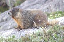
On returning to camp, I could only think about tomato soup and french onion soup, the nearest instances of which were two days away. If I was after salt, then I wasn't having any vegemite cravings. I had brought some miso soup and I enjoyed that for dinner, but I didn't try anything else. I sat on a rock and watched the marmots playing several 100' below. A marmot started across a snow field below me, and suddenly stopped in the middle. With a raptor in the area, this wasn't a great spot for a golden red marmot to be sitting. He didn't move for minutes and I couldn't figure out why he would stay there, exposed for so long. Then I realised he might be worried about me wanting him for dinner. If it was the same fellow who'd visited our campsite the evening before, I didn't expect he'd care about us at all. I waved to him to test my theory and he shot off across the snow into the grey rocks. A hypoxic australia at 400m range looks more threatening than a raptor to a marmot.
Because of the altitude effects, the trip had felt like a week with mononucleosis/glandular fever, in a coldroom, with a stiff breeze. It was 3 months before I started drinking much coffee again.
Effect of altitude on hunger
I checked the hunger problem out back at sea level. Puffing up a hill I wasn't hungry at all. I had to sit down a bit before I wanted to eat. Clearly, getting more haemoglobin would take a month or so. DPG, the haemoglobin modulator should change in minutes. The other possibility was that the muscles were dumping lactic acid into the blood for the liver to process. I couldn't see this as a problem as I my liver can process lactic acid to the level of strenuous activity and it should be able to clean up whatever small amount of lactic acid I was producing from just walking around. I found it hard to believe I was in this much distress with oxygen down 30% when at sea level I could do strenuous activity, which I expected would bring my blood O2 level down more than that. I remembered that the south american natives chewed coca leaves to aid carrying heavy loads at high altitude in the Andes, but then the cocaine was more to help with the pain of the load than the attitude. (see this.
On my return to North Carolina I looked on the internet for preventive measures - I didn't want to go through this again for any future 1 week trips if there was anything I could do at sea level. Coming off altitude this time was more like recovering from being seasick, it just slowly went away. Increased aerobic conditioning must help I thought. The webpages describing preparation for altitude, for people going to Macchu Picchu in Peru or to Kilimanjaro, or Iron man competitors, or for runners competing in the Pike's Peak marathon just tell you to go there 3 weeks ahead of time. Most of the symptoms of altitude (acute mountain sickness, AMS) such as headaches and nausea are due to the odema (water retention) caused by low oxygen and are not directly a matter of cardiovascular condition (e.g. see Adventure Dynamics website). While the people climbing Kilimanjaro may be a pack of cut-lunchies, anyone contemplating a marathon at altitude presumably is in peak cardiovascular condition already. Presumably my problem was odema and not a lack of cardiovascular conditioning, as I had thought while I was on the trip. I've heard that your brains shrink as you get older, in which case I shouldn't be suseptible to AMS anymore (I guess I could still get the pulmonary odema). Apparently most of the symptoms of AMS subside in 3-4 days. One solution is the prescription drug diamox, a diuretic which also makes you breath faster (you need to increase your water intake correspondingly). Apparently eating lots of carbohydrates (> 70% of your calories) and drinking lots of water is essential to handle AMS (even if it makes you throw up).
It would seem there isn't much preparation you can do at sea level. The only thing available for people at sea level is an airtight tent that allows you to sleep at 10,000'. I don't know why people can't sleep at sea level breathing a mixture of 87% nitrogen and 13% oxygen instead of normal air (78% nitrogen and 20% oxygen). Presumably you could buy cylinders of gas and put them next to your bed and wear a high altitude face mask for the night. I'm sure it would be cheaper than $10k. I then realised that by sleeping with a bedsheet over my face, I would be breathing air with reduced oxygen. I found that I didn't like having my face covered and couldn't go to sleep. Presumably the high carbon dioxide level raises alarms in your body, which attempts to get you to better air. Maybe next time I'll just try diamox.
[Comment from RNC: we found similar problems at altitude. Above 4000 metres in Nepal, we could not handle any sorts of fats. However, plain carbohydrate like rice and bread was fine, and drinking lots of water was very helpful.]
Other Notes
American Parks and Forests
In the US a National Forest is a piece of Wilderness with less restrictions than a park. You can camp pretty much wherever you want, whereas in National Parks you can be quite restricted. The wilderness quality is often as good as a National Park. Our trip was in a National Forest designated as a wilderness area, which places extra restictions on its use.
People can hunt in Nation Forests (and some National Parks) - in season. Hunting season used to start on the same day each year for all fauna, resulting in 250,000 hunters in the woods on opening day, all shooting at each other (a hunter in a bright orange jacket and cap is easy to confuse with a deer). I remember growing up in Australia, on the first day of the US hunting season, when the newsreader on TV would announce with a half smile, the number of hunters that had died that day. My brother would make an aside "a spokesman for the ducks reports that casualties are light". Of course this couldn't go on forever, or there'd be no-one left to do the hunting, so now hunting season starts on different days for different animals and for different methods (bows, guns...) and the carnage amongst hunters has thankfully dropped.
Unfortunately Pb is still used for bullets (and for fishing sinkers). Instead of blasting hundreds of pounds of lead to the environment each year, you'd think by now that hunters would have found more ecologically friendly ways of killing wild animals. The US DoD at least has taken a step in that direction, replacing the ozone depleting R12 freon in the cooling for its nuclear warheads with R134a thus ensuring that the country's entire missile defense system is ozone layer friendly.
In Australia, names sounding like "National Forest" are used for pieces of land turned over to commercial growth of non-native trees. In the US, these commercial forests are on private (company owned or leased) land which the company controls (i.e. you aren't allowed in there, even to save ancient redwood trees).
Desert Land
The concept of a desert as being a dry place is new. The original meaning was from the French word, desert (pronounced like the Eng. dessert) which was used in the sense of deserted or barren. The current meaning of desert, an area with <10"/pa rain, came after the exploration of the arid american west in the 19th century.
Part of Acadia National Park in Maine (NE of USA) is Mt. Desert Is., an island of deserted mountains (named by Champlain) that have been cleaned of topsoil by the recent glaciers. (You can buy calendars of Acadia Park anywhere in USA, and there are 100's of webpages offering lodging in the area of the park, but do you think I could find on the web a nice photo of the treeless pink granite hills of Mt Desert Is web? noooo.)
Copyright © 2002 text - Joseph Mack.
Copyright © 2002 images - Steven D. Carson.