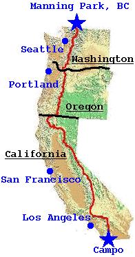
The Pacific Crest Trail (PCT) lies on the west coast of the United States. It starts at the Mexican border near the small town of Campo, moves through the southern Californian deserts, then enters the Sierra Nevada mountains. In Northern California the trail enters the Cascade mountains and continues through Oregon and Washington to the Canadian border, at Manning Provincial Park. It covers 2650 miles or 4260 kilometres.
Highlights of the trail are the superb mountain scenery, barren deserts, high glaciated passes, deep glaciated valleys, alpine meadows strewn with wildflowers, lakes, streams, rivers. For weeks at a time the trail can remain above 7500 feet, (ie higher than Mt Kosciusko). Hiking the trail becomes your complete lifestyle for months on end.
The trail is well marked and easy to follow, although occasional wrong turns are to be expected. Of the 200-250 who attempt a thru-hike each year about 50-70 finish, depending on the weather. In 1998 (a high snow year) as few as 5 completed the whole trip.
Normally the PCT is hiked from South to North, starting in late April to early June. This allows transit of the southern deserts before it gets too hot and entry to the High Sierras in early to mid June when the high passes are becoming clear enough to cross easily and safely. If it's a heavy snow season in the Sierra's then starting later or traveling North to South might be the way to go.
Hiking the whole PCT in a single season takes between 4 and 6 months. People attempting this are known as "thru-hikers'. Many people hike sections -'section hikers' - sometimes taking many years to complete the whole trail.
Your luck with the weather will vary. I had a total 2 hours of light rain in all of Washington. I met people who in 2000 had 23 wet days out of 26 in Washington. The wettest day I experienced on my trip was in the Mojave Desert - go figure.
Most serious Australian hikers will have all the gear they need to start the PCT. Maybe consider the addition of an ice-axe and instep crampons (combined with the knowledge of how to use them) if starting early and expecting to hit the snow in the Sierras. Do consider footwear very seriously.
There are many discussions of gear in the PCT-L mail list (see below) -follow the discussions and see what suits your own hiking style. Common debates cover shelter, rain-wear, footwear and cooking gear.
Stoves on planes
As at 2002 the situation was unclear with regard to carrying fuel stoves and fuel bottles on planes. Consider buying a new stove in the US - a small expense compared to the overall cost of the trip. Many thru-hikers use homemade alcohol stoves and solid fuel stoves.
It will take about 6 weeks to get all the required paperwork prepared from here in Australia. None of these are any trouble to get for Australian citizens.
Learn to think in pounds, feet and miles. Thats what people use in the US
The best way to plan from here in Australia is to use the Internet -there is a wealth of on-line information available. Particularly useful is the PCTA website and the great PCT-L mailing list and its archives. See the "Links" section below.
And there is Craig's PCT planner - an amazing program that allows you to plan the whole itinerary for your hike - go and start using it early in your planning, it will make many issues clearer.
Typically it takes 3-5 days of walking between resupply points, with a worst case of 8-9 days in the Sierras. Many people prepare food parcels and have friends mail them to designated towns. This is not a practical option for most Australians. However, it is very practical to resupply-as-you-go, buying food at nearby towns. Hitchhiking is usually very safe and easy.
There is a two volume set of guide books available - these are essential. They contain complete trail descriptions and maps. You do not need anything else to do the trail. You do not need to carry maps.
Strongly recommended is the Data Book, a summary of distances between way points on the trail. There is also a Town Guide with descriptions and maps of all the towns that lie close to the trail.
These books can be purchased from the PCTA web site, see Links below.
The following links are a small set of starting points for someone planning a hike. There are many other places on the web - a decent search engine will reveal much, much more. Especially worthwhile are the many hiker journals.