main

Archive | Conservation

A Concreted Coast

Central Coast Council approved a Master Plan for a permanent Walkway in March 2012 to provide a fully signposted concrete path which provides a safe route from Copacabana to Winney Bay, including a new north-facing and wheelchair accessible lookout at Captain Cook Lookout.

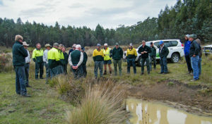
Concerned local Joy Cooper reached out to us recently concerning the concreting of the 5 Lands Walk in Winney Bay. She is not the only walker. Local residents are concerned about the damage done to ecological and cultural heritage of what was once a bushwalk track, now an 8 metre wide footpath that Joy Cooper describes as a ‘concreted coast’ that appeals more to tourists than walkers. As local walkers, bushwalking enthusiasts and trailblazers is there a line we draw when suggesting maintaining and improving tracks? We know it’s certainly something walkers can’t help wondering when seeing drastic changes on their favourite walk. Joy’s concerns below:

What a wonderful announcement from Adam Crouch with the huge sum of $4.6 million for his electorate, and for the Bulbararang cliff top walk.

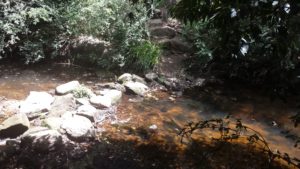
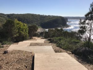
What a shame the original plan for the walk had veered so far off the original plan. Having a bush-walk which makes it safer for walkers is wonderful and to link the two seaside village communities of Copacabana and Avoca Beach is superb. However to clear large areas of bushland to put in the walk way and concrete it, is a travesty and not needed, nor good practice.

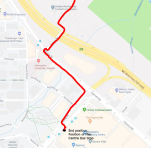
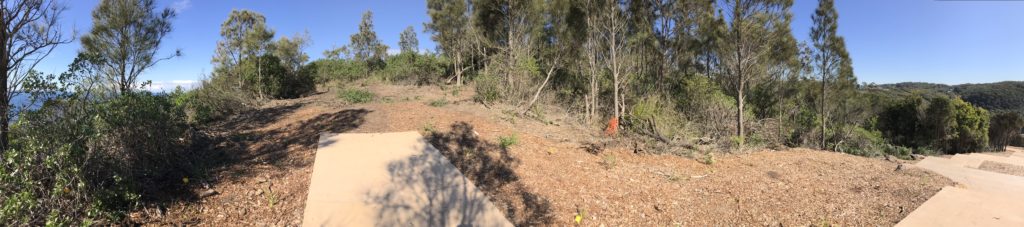
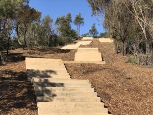
If the current stairwell nearing completion is any indication residents will not be pleased. While residents were told in a community meeting the stairs were only 2 metres wide, the clearing of bushland has been more than 8 metres for more than 720 metres, and each week it is easy to see the clearing gets wider with more trees being damaged.

While machinery and fuel were to be kept in a compound on the old farm house site, sadly both were stored in bushland resulting in even more bush being cleared and damage occurring.

More than 60 trees were removed for this ‘nature walk’ for all to enjoy and remaining trees near the path were to have special protection to prevent any damage while construction was occurring, yet that did not happen and there have been numerous trees with damage and limbs torn off and thrown into the bush.

While the damage has occurred with the stairway to nowhere, despite numerous requests for it to stop before it was started, there was insistence by council for the stairs to be built, so the funding wasn’t lost. The cliff top ‘nature walk’ along Bulbararing is still to start. Residents should be concerned once again little or no information is made public until it is too late and the destruction has occurred.

While the original 2012 master-plan clearly shows the walk way through Winney Bay and along the Bulbarang cliff top is to be bush track and even shows images with no concrete to be seen, the current plans are nothing like that. The current plans are for a concrete pathway and vehicular access to market stalls, cantilevered cliff top platform for destination weddings along with a whale carcass shaped bridgeover a huge ravine which has very sorrowful memories for some in the community.

The original master plan mentions ‘existing areas of unique, intact native vegetation which high aesthetic appeal’ in Winney Bay and along the Bulbararing Headlands and there is mention of the need to keep the infrastructure ‘simple and discreet’. However the current plans in my opinion are nothing like that.

So, while we have a huge divergence from the original intention of the upgrade of the bush track and no consultation with the community, we also have the state government/Central Coast Regional Plan 2036/. With the second goal being to ‘Protect the natural environment and manage the use of agriculture and resource lands’. How we can do this and remove bushland by concreting vehicular access and concrete paths with large areas of batter doesn’t correlate for me.

Additionally, we have the recently adopted/ONE-Central Coast/adopted by Central Coast Council and the numerous mention of the need to protect our natural environment which is ‘cherished’. There is even mention of ‘expanding of the Costal Open Space System COSS’. Ironically, this Winney Bay area and Bulbararing cliff top are already part of COSS and there are numerous endangered ecological communities in the area.


What use are these documents if the powers that be can’t follow their own plans? What hope do we have of preserving bushland if it is degraded, neglected and then concreted? How can we connect to a place if it is all concreted?

Winney Bay and Bulbararing headland deserve the $4.6 million dollars which should be spent on employing trained people to rehabilitate the area and remove the bitou bush and harvest and grow local provenance vegetation, bringing back the natural beauty of the areaand providing the ‘bush track’ as originally intended. Not concrete creep and destruction.

Horse riding in wilderness areas

There is still opportunity for walkers to provide feedback on the proposed changes after trials of horse riding between 2014 and 2016 in parks managed by NSW National Parks and Wildlife Service (NPWS).

The amendments have been proposed to allow horse riding in wilderness areas, which includes 30km of the Nine Mile and Ingeegoodbee management trails in the Pilot Wilderness Area in Kosciuszko National Park, accessed via the Barry Way. The trial was from April 2014 to April 2016.

The public exhibition of these amendments has been available for comment since 22 June and will close 7 August 2018. You can also view the Horse Riding in Wilderness Trial Monitoring Program Final Report.

We urge Bushwalkers to make comment concerning the amendments particularly if you have walked in this area, your submission needs to be received by 7 August.

As per the guidelines:

Write clearly and be specific about the issues that are of concern to you.
Note which part or section of the amendment your comments relate to.
Give reasoning in support of your points – this helps avoid misinterpretation and makes it easier for us consider your ideas.
If you agree or support a particular part or idea in the amendment, please tell us.
If you disagree, please tell us specifically what you disagree with and why you disagree.
If you can, suggest solutions or alternatives to managing the issue.


Also note:

The proposed amendments can be viewed at https://engage.environment.nsw.gov.au/consult OR

  • OEH Customer Centre (Level 14, 59–61 Goulburn St, Sydney)
  • NPWS Narooma Office (corner Graham and Burrawang Streets, Narooma, NSW)
  • Braidwood Library (Park Lane, Braidwood, NSW)
  • Snowy Region NPWS Visitor Centre (46 Kosciuszko Road, Jindabyne, NSW)
  • Tumut NPWS Visitor Information Centre (5 Adelong Road, Tumut, NSW)
  • Cooma Visitor Centre (119 Sharp Street, Cooma, NSW)
  • Tumbarumba Visitor Information Centre (10 Bridge Street, Tumbarumba, NSW)
  • NPWS Walcha Office (188W North Street, Walcha, NSW)
  • NPWS Gloucester Office (59 Church Street, Gloucester, NSW)
  • Walcha Shire Council (2W Hamilton Street, Walcha, NSW)
  • Walcha Visitor Information Centre (29W Fitzroy Street, Walcha, NSW)

You can provide your submission in one of the following ways:

  1. use the online submission form at https://engage.environment.nsw.gov.au/consult
  2. email your submission to parkplanning@environment.nsw.gov.au
  3. post your submission Manager Planning Evaluation and Assessment, PO Box 95, Parramatta NSW 2124. 


Your submission will be provided to a number of statutory advisory bodies (including the relevant regional advisory committee and the National Parks and Wildlife Advisory Council). Your comments on the draft plan amendment may include ‘personal information’. OEH complies with the NSW Privacy and Personal Information Protection Act 1998, which regulates the collection, storage, access, amendment, use and disclosure of personal information. See OEH privacy webpage for details. Information that in some way identifies you may be gathered when you use our website or send us correspondence.

If an application to access information under the Government Information (Public Access) Act 2009 requests access to your submission, your views about release will be sought if you have indicated that you object to your submission being made public.

Warragamba Dam wall

If the Warragamba Dam wall is raised by 14 metres, the dam will hold over two additional Sydney Harbours, 4,700 hectares of World Heritage listed National Parks, 1,800 hectares of declared Wilderness Areas and 65 kilometres of Blue Mountains’ wild rivers would be inundated and destroyed.

It is arguably the most protected natural landscape in Australia. The Coxs, Kowmung, Kedumba, Natti, Wollondilly and Little Rivers would be flooded for months at a time.

Many of our Club members throughout NSW visit these areas.

Without our support, internationally significant environments that are recognised in the Blue Mountains World Heritage listing would die from sedimentation, erosion and invasion of exotic plants.

There are 48 threatened plant and animal species which inhabit the proposed inundation area.

Species such as the vulnerable Camden White Gum and the Kowmung Hakea are predominantly found within the inundation area, with the dam raising likely pushing many species close to extinction.


The area of proposed inundation is home to hundreds of Indigenous heritage sites.

Delicate rock art and marker sites will be forever destroyed if they are flooded by the raised dam for any length of time.

“Our history and our stories are in the landscape that surrounds Lake Burragorang. When Warragamba Dam flooded the valley in 1960, our lands and cultural sites were flooded. We do not want to see this story repeated with the remaining sites. Each time we lose a site, we lose part of our identity.”

– Kazan Brown

Gundungurra traditional owner and Warragamba resident


Information and photos courtesy of the Colong Foundation for Wilderness.

For more information, visit their website.

Myrtle Rust

Myrtle Rust is a member of the guava rust complex caused by Puccinia psidii, a known significant pathogen of Myrtaceae plants outside Australia, and was first detected on the Central Coast of NSW in 2010.

It has now firmly established itself along the east coast of Australia from southern New South Wales to far north Queensland, and in some parts of Victoria. Its spores spread rapidly and by air, making whole eradication unfeasible.  However, areas such as Wambina Nature Reserve have eradication plans and are quarantined.

Tasmania’s efforts to educate bushwalkers included a Myrtle Rust ID card.

Studies have found that at least 347 Australian Myrtaceae species are susceptible.

The most notably affected are eucalypts (Eucalyptus, Angophora and Corymbia), paperbarks and bottlebrushes (Melaleuca and, formerly, Callistemon), and tea-trees (Leptospermum).

Myrtle Rust attacks young, soft, actively growing leaves, shoot tips and young stems, as well as fruits and flower parts of susceptible plants.

The first signs of myrtle rust infection are tiny raised spots that are brown to grey, often with red-purple haloes.

After infection, the spots produce masses of distinctive yellow spores.

The fungus is spread very easily by these spores through the air and water, and can also accumulate on clothing, gloves, hats, tents, watches, wristbands and other gear.

Bushland that we visit could be infected with Myrtle Rust. Remember to arrive clean and leave clean, pack light, carpool when possible and leave cars in carpark areas or away from bush.

If there is any chance that you have encountered the fungus, change into fresh clothes and wash your hands, face and footwear to prevent it spreading. Clean your shoes with a 70% methylated spirits or benzyl alkonium chloride disinfectant.

Standard washing-machine use with detergent will kill Myrtle Rust spores on clothing, gloves, hats and other items suitable for the washing machine. Brush up on how to Clean Your Gear and see our Solutions page for information.


Notes:

https://www.invasives.org.au/project/myrtle-rust

https://www.dpi.nsw.gov.au/biosecurity/plant/established-plant-pests-and-diseases/myrtle-rust

http://www.environment.nsw.gov.au/resources/pestsweeds/110683myrtlerustmp.pdf

http://dpipwe.tas.gov.au/Documents/myrtle.pdf

https://invasives.org.au/wp-content/uploads/2017/11/Case-Study-Myrtle-rust.pdf

https://invasives.org.au/wp-content/uploads/2014/02/fs_myrtle_rust.pdf

Update:

https://www.abc.net.au/news/science/2019-12-04/myrtle-rust-fungus-invasive-species-killing-native-trees/11730738

Phytophthora Cinnamomi

Phytophthora Cinnamomi is a fungus that grows inside a susceptible plant’s roots, reducing its ability to transport nutrients to the rest of the tree, killing it or making the tree look sickly (generally known as Dieback).

Trees and plants infect each other by root-to-root contact. However, on a downward slope Phytopthora can travel up to 40 metres per year through soil and mud, and can lay dormant in dry soil.

Some examples of NSW affected areas are Wollemi National Park, Barrington Tops National Park and Mount Imlay National Park where flora and fauna have been radically changed by it. The flora suffering Dieback are quarantined to limit the spread. The infected flora are still important, providing a habitat for species and preventing salinity and erosion in the area.


As bushwalkers, we can play our part when walking nearby infected areas, by assisting in keeping other areas free of infection, limiting the spread and reducing our impact. It’s Sweet to Walk Soft!

Unlike diseases such as Myrtle Rust, studies have found that contaminated trees do not contain the fungus on leaves or branches, but the fungus can still be transported by touching infected roots, water, soil or mud.


Read all signage in our National Parks and follow their instructions, staying out of quarantined areas, as well as using Hygiene Stations when available to brush down gear. Unless with an experienced leader with background training and knowledge in the area, we must stick to tracks and paths while bushwalking and/or driving, and limit the amount of vehicles we take.


To learn more about responsibility in the bush, join your local bushwalking Club, take one of our FREE courses or try volunteering to protect our lovely National Parks.


Notes:

http://www.environment.nsw.gov.au/determinations/PhytophthoraKTPListing.htm

http://www.environment.nsw.gov.au/threatenedspeciesapp/profile.aspx?id=20026

http://www.cpsm-phytophthora.org/

https://www.dwg.org.au/

http://barmac.com.au/problem/phytophthora-cinnamomi/

David’s Lane Cove River Minimal Impact Training walks

David will be leading two Minimal Impact Bushwalking Awareness Walks in Lane Cove National Park and this webpage shows the planned route. To book for these walks go to: Bushwalking NSW Minimal Impact Bushwalking Training Events

The walk will start at the Koonjerie Picnic Area in the Lane Cove National Park:

The walk will parts of the Great North Walk on the east side of the river after crossing at the Lane Cove Weir:

The walk goes back across the river near Christie Park where the river is not very wide or deep, and there are many rocks creating the crossing:

The walk will finish at the Macquarie Centre:

From here a 545 bus can be caught back to the starting point or Chatswood Station.


Chytrid Fungus

Chytridiomycosis is a disease caused by the Chytrid Fungus (Batrachochytrium dendrobatidis), which has been causing sporadic deaths and other times a 100 per cent mortality rate to different species of frogs.

So where is this fungus?

According to research, the Chytrid Fungus is now widely distributed in Australia in water or wet soil and has caused six species of frog to become extinct.

In particular, the fungus is along the Great Dividing Range and adjacent coastal areas in the eastern mainland states of Queensland, New South Wales, Victoria, eastern and central Tasmania, southern South Australia, and south-western Western Australia, and there is no known way to remove it.

In NSW, 22 species, more than one quarter of the total NSW amphibian fauna, have been diagnosed with the disease. There are 3 frogs at a high extinction risk in NSW, identified by their low population, ongoing state and predicted decline of population size. I’ve listed them below:


Spotted Tree Frog (Lioria Spenceri)

Southern Corroboree Frog (Pseudophryne Corroboree)

Northern Corroboree Frog (Pseudophryne Pengilleyi)


You can find out if these frogs are in your favourite walking area by using https://www.frogid.net.au/learn. Just plug the frog’s English name in the search bar for some info, pictures and frog sounds.

There are various fieldwork programs in place made from volunteers, frog experts and enthusiasts. The Northern Corroboree Frog Captive Breeding and Release Program is one example; the frogs take 5 years to mature, so breeding, raising frogs followed by their release and monitoring involves a timeline of over 8 years.

While there is not yet evidence of being able to remove the disease, some research has found that the frogs are building an immunity to the fungus, so with long-term methods like the Captive Breeding Program, our NSW frogs still have a chance to adapt.

As bushwalkers, we can play our part too.

If we’re sloshing through creeks near where frogs hang out, we might want to look at brushing up on our Solutions and have a think about how we clean our gear before and after the walk.

We can help mitigate controllable threats, such as habitat degradation, and preserve our wild places!

For more info, see the links at the end of this article.


Notes:

http://www.environment.gov.au/system/files/resources/279bf387-09e0-433f-8973-3e18158febb6/files/c-disease_1.pdf

http://www.publish.csiro.au/wr/WR15071

http://www.frogsafe.org.au/disease/chytrid_bg.shtml

http://www.fats.org.au/

https://frogs.org.au/frogs/search.php

Advice to the Minister for Sustainability, Environment, Water, Population and Communities from the Threatened Species Scientific Committee, including locations:

Spotted Tree Frog (Lioria Spenceri)

Southern Corroboree Frog (Pseudophryne Corroboree)

Northern Corroboree Frog (Pseudophryne Pengilleyi)

Weeds, pests and diseases

While we have a strong ethos of ‘treading lightly’ when out in the bush, it’s all-too-easy to unwittingly spread weeds and diseases that can kill wildlife and destroy wild places.

Weeds, pests and diseases are major threats to Australia’s native plants and animals. They can hitch a ride on muddy hiking boots, in wet fishing gear or even hidden on the dirty rims of your car.

So what are these weeds, pests and diseases affecting NSW?

Here are the main ones we are looking out for, and they can be contained and prevented from spreading by all of us doing our part. Tread lightly!

– Chytrid is a fungal disease blamed for frog extinctions here and overseas. It is transmitted between frogs or through contact with contaminated water.

– Phytophthora is a root rot that destroys native plants. It is spread in mud and soil on walker’s boots, bikes and vehicles.

– Didymo, also known as ‘rock snot’, has yet made it to Australia but can be transported on wet fishing gear. It has devastated riverbed habitats in New Zealand.

– Myrtle Rust is a fungal disease which affects new growth in eucalyptus, melaleucas, bottlebrush and other Myrtaceae plants. The yellow/orange spores are easily spread on clothing, gear and vehicles.

– Weeds radically alter ecosystems, smothering and outcompeting native plants and robbing wildlife of food and shelter.

– Intestinal bugs picked up travelling don’t always show symptoms in some people but can spread by poor toileting near creeks and severely affect other people and wildlife.


Bushwalking NSW has just endorsed the latest version of the “Keep your gear clean in the wild” brochure by the Invasive Species Council. Stay up to date on the invasive species that are threatening our favourite bushwalking tracks by checking out their website www.invasives.org.au.

Frogs and Sunscreen


If you’d like to enjoy a swim on your bushwalk, come prepared to keep the water clean for our frog-life by having your skin free of insect repellent, sunscreens, soap and fragrances.

This summer, many of our walks will involve swimming holes, creek crossings, canyoning, kayaking and lilo trips, so we’re bound to come close to our froggy friends, although you might not spot them.

They’re also very sensitive, and absorb chemicals through their skin to their own detriment.  The Fleay’s Barred Frog are one example of a frog species threatened almost to extinction attributed to sunscreen and insect repellent.

Amphibian skin is unique, being physiologically active and able to absorb air, water and electrolytes. We don’t hear much about frogs – experts are still puzzling over their unique anatomy.

Chytridiomycosis is one example of a disease that affects amphibians worldwide, but how it does so, and its true impact of frog populations is not certain. Some species of frogs seem unaffected by such pollution while other species have been declared extinct.

Before we take on the outdoors, we can think about the skin products we intend to use. Even skin products and cosmetics that are biodegradable with natural ingredients, while certainly a good thing, are not environmentally friendly to our frogs.

Instead, we can take care of our skin and the environment by using a wide-brimmed hat, or a cap with a neck flap. Take a long-sleeve rash guard if you’re susceptible to sunburn while swimming.

Also, look at alternative technologies for keeping mosquitos, ticks and leeches at bay such as doubling up on socks, use of gaiters and long-sleeve, loose fitting shirts.

Insect-repellent clothing

Insect-repellent clothing does not provide complete protection on its own, and begs the question – will it affect our environment? This technology uses a pesticide called Permethrin, which has been known to come out in water. Tests have shown the pesticide rapidly breaks down (rather than clump together like other chemicals), and is biodegradable in 1-16 weeks – but it is highly toxic to insects and fish.

Before we get lost down the rabbit hole, it seems the main thing is we be mindful with the ‘slop’ part of ‘slip, slop, slap’. Think twice about sunscreens or insect repellent before you dive into the water this summer, and choose your walks wisely!!


Sources:

http://www.alertdiver.com/Sunscreens-Coral-Bleaching

http://www.wildswimmingaustralia.com/sustainable-wild-swimming/

http://emag.bushwalk.com/BWA201612.pdf

https://www.environment.gov.au/system/files/resources/0cc789ea-5551-4d6f-ace3-5952c9cd0a5f/files/tsd06fleay-barred-frog.pdf

http://www.environment.gov.au/system/files/resources/279bf387-09e0-433f-8973-3e18158febb6/files/c-disease_1.pdf

http://healthcenter.indiana.edu/answers/insect-precautions.shtml

https://www.epa.gov/insect-repellents/repellent-treated-clothing

http://www.environment.nsw.gov.au/threatenedSpeciesApp/profile.aspx?id=10537

Save Western Sydney Bushland

Dear nature conscious bushwalkers,

Keep in Touch

Is your club doing something to protect your local environment or some place further away? Perhaps you are concerned about a nature protection issue near you and would like to spark discussion about it or see if BNSW can help take action on it. Send me an email in this case. I love receiving mail. I’ll endeavour to respond to you quickly. My email is conservation@bushwalkingnsw.org.au. Please get in touch.

Save Western Sydney Bushland

Do you enjoy a refreshing green patch in Western Sydney once in a while? Would you like to in the future? The NSW government is warning us that future opportunities may be limited due to housing expansion and development prospects in this area. Read ahead to find out more about what’s going on and how you can ensure that important areas are saved.

The Total Environment Centre (TEC), powered by the wonderful Corinne Fisher and her dedicated volunteers and associates, keeps the world up to date on the state of development around Sydney and its surrounding area. Today, TEC has a warning that will make a bushwalker’s blood boil:

The NSW Department of Planning is right now developing a strategic ‘sustainability’ plan for 7 chosen areas in Western Sydney. This will determine which bushland areas will be developed and which will be saved. The Local Government areas to be affected are: Campbelltown, Camden, Fairfield, Hawkesbury, Liverpool, Penrith and Wollondilly.

As a keen bushwalker, I have certainly been walking in these areas and I suspect many of our clubs run trips around there two. There are some stunning adventures to be had, and furthermore some ecosystems that are clearly brimming with life, flora, fauna and fungus that does not deserve to be bulldozed to oblivion.

Please HELP.

TEC and Bushwalking NSW invite you to take a stand and give a voice to these voiceless ecosystems at their forum on Thursday, November 16th from 6:30pm to 8:30pm at the Western Sydney Leagues Club in Leumeah (details below), however here are a couple of suggestions.

  1. PLEASE RSVP at this link, on the TEC website. They need to know how many people will be coming because there is limited space in the venue.
  2. Why not bring a contingent from your club along by making it a club event?
  3. Maybe you could bring some of your conservation minded friends or an open-minded family member.

Event details:

When

November 16, 2017 at 6:30pm – 8:30pm

Where

Western Sydney Leagues Club (Gardenia Room)
10 Old Leumeah Rd
Leumeah, NSW 2560
Australia
Google map and directions

TEC Contact Person

Corinne Fisher
cfisher@tec.org.au
02-92115022


Post by Sierra Classen, Bushwalking NSW Conservation Officer