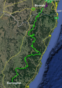

The Great Escarpment Trail
Going on country to experience firsthand the natural attractions of our great land is a privilege available to all.
The trail will enable those undertaking low impact recreation activities such as walking to experience our bush heritage as they pass though national park, state forest, rural landscapes, historic sites, country roads and towns.
Whether done in toto over an extended period, or in increments over a period of years, the Great Escarpment Trail will become a valued asset to enhance the health and wellbeing of both Australian residents and international visitors as they take on the challenge of walking it in a manner suited to themselves.
Not only will they discover our natural wonders, the scenic beauty, sounds and smells of our bushland, but they will discover themselves as they satisfy their wanderlust
Some statistics on the full trail:
- Length: 1454.38 km (Lagoon Pinch Picnic Area to Boonah Visitor Information Centre.)
- Maximum elevation: 1582 m – Flank of Polblue Mountain, Barrington Tops NP.
- Minimum elevation: 6 m – Bellinger River Bridge, Bellingen.
- Average elevation: 820 m – inside the altitude band for Gondwana Rainforests of Australia.
- Total elevation gain:
- Travelling towards Boonah – 42681 metres
- Travelling towards Barrington Tops – 41490 metres
- Average gradient:
- Travelling towards Boonah – 2.93%
- Travelling towards Barrington Tops – 2.85%
Maps
Maps for the entire trail can be found here. Sections are named after the parks/features that they traverse. Where necessary, sections are further broken down into subsections each of roughly a day’s walk.
Ground truthing
We need your help to test out the walk and give us feedback. Thanks to Paddy Pallin we are offering ground truthers prizes for the best photos and feedback. Learn more about the competition here
Trail Governance
A governing body is being created with the objectives to promote and oversee the use of the Great Escarpment Trail (GET), and to foster the development and maintenance of the GET.
The governance body would apply for grants to support its activities, provide information on the trail and promote its use, run a website and smartphone app (funding permitting) with trail information, develop and deploy signage along the trail. It could also organise volunteers to maintain the trail, and organise events on the Trail.
If you are interested in being involved just reach out to us at: https://www.bushwalkingnsw.org.au/contact-us/
