29 December 2019 – 5 January 2020 Trip Report by Anne Turner – for joint SPAN OUTDOOR CLUB and NSW NORDIC SKI CLUB walk
In October I planned a New Year Snowy Mountains adventure walk. What about Paddy Pallin’s famous K2K route? Kiandra to Kosciuszko? After contacting SPAN Bushwalking Club and Nordic Ski Club I quickly got 3 willing partners in crime.
We studied maps and websites and John Chapman’s great Australian Alpine Walking Track (AAWT) book (which goes from south to north rather than north to south). We decided on seven nights, the last night camping just out of Dead Horse Gap, with a short walk the next day then drive to Thredbo for breakfast (proper breakfast, muesli would be banned!)
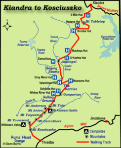
We would start at Kiandra and mostly follow the AAWT to Dead Horse Gap. After Mackay’s Hut we would go off track (a break from fire trails), around the eastern side of Jugungal along Bogong Creek and Jugungal Saddle then up Jagungal. We would then go south to Mawsons Hut, and camp near water somewhere. Then along the Kerries and to Gungartan, across to the Rolling Grounds over Consett Stephen Pass and along the main range finishing with Rams Heads. What a plan – I got excited every time we looked at the maps!
The weather looked clear but bushfires were a worry as it had been very hot and we were in an extended drought. We discussed whether or not to go and decided to proceed as the park was open and we would keep our wits about us.
We didn’t have suitable car so would drive a hire car, leave it at Dead Horse Gap, and take a transfer from Dead Horse Gap to Kiandra on Sunday 29th December. We left Sydney on 28th December and on Sunday morning were on track by 11.30am walking towards 9 Mile Creek. There was water in the creeks which was good news. The march flies were around, not too bad at the beginning, but worse as it heated up.
Sue had given us a challenge to make up a limerick or haiku about each member of the walk. We were not particularly successful but there were some very funny conversations. The downsides were our heavy packs, overshooting 9 Mile Creek and walking up a horrible hill just to turn around and go straight back down. I’m not sure if singing ‘The Grand Old Duke of York’ helped anyone’s spirits at that point or not!
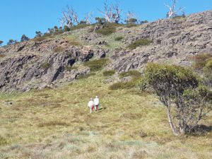
Day 2 saw us climbing Tabletop Mountain (sans packs) with the outline of Jagungal visible though smoke haze to the south. A pair of walkers we knew were going our way and joined our group. We got to Happy’s Hut in the afternoon and enjoyed its shady veranda while overhead was smoke and the red sun. During the afternoon we were joined by Catherine, walking solo, and later Ryan and his father in law Peter.
New Year’s Eve, 31 December 2019, was very warm and concerningly there were burnt leaves falling from the sky. While the sky overhead had a big billow of high smoke coming from the north east, the air around us was pretty clear. We decided to walk to Mackay’s Hut where we could exit the park if things deteriorated.
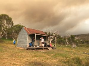
Catherine headed out before us and Ryan and Peter left shortly after us. As we walked on Tolbar Road and Grey Mare Fire Trail the light changed from clear to red then dark and at times there was a surreal brightness without shadows. The smoke cloud got bigger and darker and burnt leaves kept falling. We all started looking at each other and wondering if we were doing the right thing. We planned to walk past Mackay’s Hut to O’Keefes Hut and access Farm Ridge or Round Mountain fire trails if necessary.
As we rested Catherine came striding towards us having turned around after making contact with the outside world at a high point. She told us that there were fires to the west of us and Bega was on fire. She had decided it was time to go east and not leave it until things went wrong and she become a burden on emergency services. As we had been considering the same thing we quickly decided to join her.
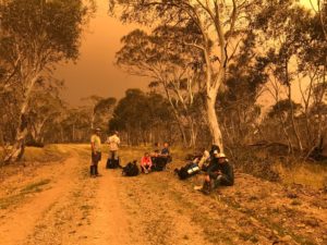
We walked back to the Grey Mare Trail and Tolbar Road crossroads and the sky kept getting darker with occasional rain showers, an eerie silence and smoke haze affecting visibility. After we had been walking for about 30 minutes we ran into Ryan and Peter.
We drew heavily on Catherine’s local knowledge of the park as we discussed our options and looked at maps. Walking back towards Kiandra to Broken Dam Hut then to the highway was one option but it would take us north west towards the smoke cloud so we decided against it. We decided to go down to Eucumbene Cove was too far and instead settled on walking north east down the Tolbar Road to Providence Portal (a little cabin community on the northern arm of Lake Eucumbene). It was close to Adaminaby and we thought it should have people there and up to date information.
The afternoon was now cool and breezy – nice walking weather if there had not been a raging bushfire nearby! We had enough rain at two points for raincoats and rolling thunder all afternoon. We heard a chopper at one point but we were in trees so couldn’t see it and it couldn’t see us. We saw a burst of new smoke on the skyline behind us and to the north and another way south of us. It must be lightning strikes we theorised and were glad to be getting out of there.
We walked about 35kms on our third and final day. Fortunately the end of Lake Eucumbene wasn’t a lake anymore as there was not enough water. Peter gave us directions and the river was so shallow and divided into tributaries that we would be able to easily wade across. This was great news as none as us had enough in the tank to do the huge walk around. It was a beautiful flood plain with lots of birds, kangaroos and white daisies. We all breathed a sigh of relief as the cabins of Providence Portal grew closer.
At about 7.30pm we were greeted by the park owner Hans riding out on his quad bike greeting us with ‘Where the bloody hell did you guys come from?’ We discovered the SES had evacuated the park an hour before. Hans got on the blower and we overheard him saying, ‘I’ve got 9 walkers that have just walked out of the bush – what am I going to do with them?’ He didn’t get an answer immediately, so we camped there the night.
We woke up to a plan. Some park residents and Hans would drive us to Adaminaby. It was New Year’s Day and the town was deserted. We then managed to get rides to Cooma evacuation centre. Ryan and Peter got a ride from Cooma back to Wagga with a friend.
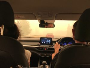
Cooma was very busy with lots of smoke and traffic as everyone holidaying south of Bateman’s Bay were leaving the fire zones through Cooma.
Catherine had organised for our drivers to be taken to the cars so they could collect the rest of us. Finally at 5pm we left Cooma and got back to Sydney around 11.30pm relieved to see home and a bed.
Today, the 9th January 2020, Fires Near Me advises the fires have cut through the northern section of the park – the area we were walking. Happy’s Hut looks like it is gone, the historic Kiandra Court House is gone and Providence Portal is surrounded by fire. Watching the horror of the fires spread over the coast and alpine areas we are so glad to be out. I was very glad to be with a calm level headed group who carefully considered the situation and our options and pooled their knowledge – thank you Catherine, Phil, Sonia, Sue, Paul, Sandra, Ryan and Peter.
Some other points we reflected on afterwards:
- The superior phone coverage of Telstra in isolated areas
- Between the group of 9 we had 4 PLBs
- The Roof Top Map gave us a bigger area in one view than looking at several toppos to make decisions
- Our phone batteries ran out – write your key phone numbers, personal and things like SES and National Parks down in your first aid kit
- Ryan had a battery pack to refresh his phone – a weight consideration, but very useful
- Where we had signal, we used Telstra phones to let contacts and the SPAN president know we were OK and what our plan was. We also contacted National Parks with the same news and told them where our cars were so they were not concerned for their owners. And then of course we followed up once we were ‘out’.
- Next time I would lodge a National Parks Trip Intention form. While it isn’t a requirement, it would have helped.
