Please note that Bob Sneddon is the sole author of this article.
Topographic Maps of NSW 2022 Series by Bob Snedden
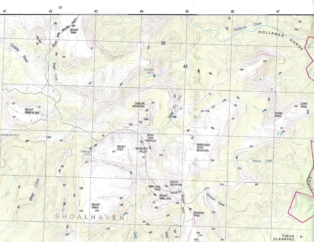
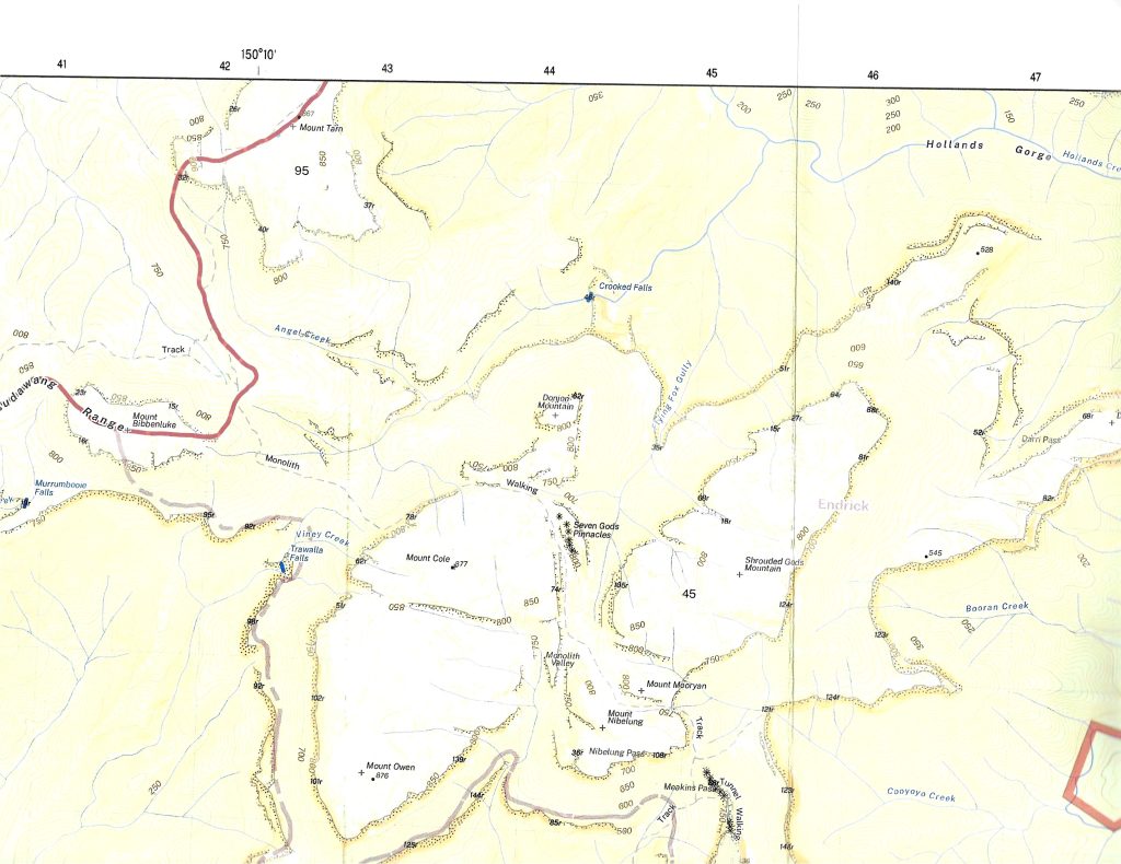
The defining feature of topographic maps are the presentation of the form of the landscape topography via the contour lines. Along with this are the vertical and horizontal grid coordinates for the “Grid References” and “GPS positioning”. The current 2022 Series fail to do this, rendering the maps unfit for purpose and therefore presenting something of a risk to the user. Those who rely on accurate landform information e.g. Rural Fire Service, NSW NPWS and bushwalkers will be directly affected. After examining 20 maps in the 2022 series covering the south coast region, from one outlet all were found to be similarly deficient.
In recent years the need to review the cost of paper map production has led the mapping authority i.e. “Spatial Services” away from the use of traditional lithographic printing. Map production is now outsourced and print production is via the use of laser digital print process. There has also been a departure from pre final run proofing and quality control. The usual casualty of department restructure has been a significant loss of intellectual content. As often happens, a renewal of a departments intellect does not mean and automatic continuity of policy. On the technical side, there is today an assumption that what you see on the computer screen is what will appear on paper. This is Not necessarily the case.
As part of the stream lining of map production, map reprinting is also subject to an “Auto generation” process whereby a reprint is initiated automatically, evidently governed by “barcode” stock records.
The deficiencies with the current 2022 series lies with the preparation of the original computer file provided to the printer. Although the contour lines and grid reference lines appear on the digital version, as seen on the computer screen. This is not what occurs with the laser printed paper copy. The defining map features are there, but virtually indistinguishable.
It is not a new problem for anyone familiar with printing processes. It just reflects the current trend of a departure from traditional approach to quality control. In short there needs to be attention given to the combination of colour selection, printing process and print stock i.e. the actual hard copy paper.
After protracted discussion issues regarding place names I have been advised:
“Spatial Services is still running an old auto generated PDF series which doesn’t include any of the updates you had suggested over the years. Business priorities have led us in different directions and whilst it remains an aspiration to produce, I can’t put a timeframe on when that might happen. Further, the circumstances remain the same in that an auto gen product doesn’t deliver the same level of information and annotation as the old traditionally produced map series”.
Errors in books, are often set aside as “typo’s”. With maps it is more than that. Where topographical information i.e. contours lines cannot be clearly distinguished and place names are incorrect, (an ongoing problem), it becomes a serious matter, critical to public safety. There is an assumption and indeed an expectation maps will be correct. The absence of critical topographic information renders the maps useless for field navigation. In the case of areas of known risk such as the southern part of Morton National Park where it surrounds the former Tianjara Artillery Training Area. The poor presentation of topographical information impacts on the management of use patterns, safety and duty of care, and can include the operation of other stakeholder activities.
Both the printer and “Spatial Services” have been advised of the deficiencies with the current series 2022 maps. Spatial Services where the files originate have stated (as above), they are aware but have no plans to correct the issue in the immediate future. It is unfortunate that “BUSINESS PRIORITIES have overtaken safety concerns and for the Government agency to be producing a product that is unfit for sale is unacceptable. Spatial Services claim they undertake appropriate proofing and quality control measures but this is clearly contradicted if one compares the 2017 and 2022 series.
A recent practice by some, is to download the map and print off the relevant section of interest. Some venture to say you can massage the file, but this requires a degree of skill using special graphic software to enhance to contours etc.
In my own view scrolling around with a computer in the field can be impractical and just grabbing a relevant section of the map does not adequately replace the spread of the full map especially when the overall terrain is unfamiliar.
All these opportunities are possible and will be argued by some. None the less, it remains the current 2022 series of maps are unfit for purpose and should not be on sale, and the “Autogen” process for restocking should be abandoned and the maps withdrawn from sale until there is a decision to correct them.
Stakeholder groups and their members e.g. Bushwalking NSW, conservation group and Rural Fire Service are encouraged to express their concern to the map publisher NSW Department of Customer Service -Spatial Services.
Bob Snedden –
Bawley Point NSW 2539
9th September 2024