

Send any comments to the maintainer Roger Caffin

People sometimes ask whether bushwalkers worry about getting lost. Most experienced walkers don't, and few have actually been lost (at least since becoming experienced!). Why is this so?
Paddy Pallin claimed to have been "never truly lost". But he defined lost as a state of mind, where you have given up, thrown in the towel, and abandoned all hope. On the other hand, all of us have suffered a "temporary geographical embarrassment", or maybe several. The difference is that while we may not know exactly where we are right now, we do know roughly where we should be and, more importantly, can work out how to sort things out.
Anyhow, some readers may remember that Winnie the Pooh was able to tell where 'home' was, once Rabbit had gone away with all his chatter, by simply sitting quietly and listening for his honey pots calling to him. The idea is recommended in principle, although for humans it sometimes works better if you use the 'cup of tea' technique. When really in strife, sit down and have a cup of tea (or coffee). A nice sweet biscuit with it helps. You will be surprised how this makes it much easier to sort out the problem.
And in the long run, all that matters is whether you get home in a reasonable time. The author was recently given a definition of a 'day walk': it's one where you get home within 24 hours of leaving home. This was said at about 2 am, as we went up Pierces Pass in the Grose Valley in the Blue Mountains. It was a long story (it was a long day!), but we were not lost! Whether we were getting home in a 'reasonable time' (or a reasonable state) was a matter of opinion: some wives did not think so. For that matter, I think our group rather startled the party camped by the Grose River as we rocketed past on the track at about midnight by moonlight and an occasional flash of a headlight.
One of the most common errors we all make is thinking you have been travelling faster than you are. It happens all the time in rough country. Another common problem is heading off in a slightly wrong direction, then rationalising (or ignoring) the local features when they don't match the map. How often have we heard (or said!) "the map must be wrong"? The two keys to handling a lot of problems is to be aware that you may have made a mistake, and to be willing to stop and check things over. Apart from that: practice with map and compass, and learn from others. And just in case, always leave your route with someone who knows what to do if they don't hear from you when they should. An email message to a friend or relative is very simple. At the very least, it helps with finding the body later so Probate can be declared.
| Contents | ||
|---|---|---|
|

Always remember: wombats are very clever fellows and they make good tracks.
There are a horde of navigational tricks you pick up over the years. A few of them are listed here: perhaps people could contribute more?
David Gibbins wrote:
This may help. I've extracted it from the following paper, available on the Internet as
"Accessibility as an important wilderness indicator: Modelling Naismith's Rule"
Steffen Fritz and Steve Carver, School of Geography University of Leeds, E-mail: s.carver@geog.leeds.ac.uk
W.W. Naismith was a founder of the Scottish Mountaineering Club and a formidable walker. His rule for walking times was laid out in 1892, and is still used to obtain a rough estimate of the time required for a given expedition (Aitken, 1977; Langmuir, 1984). It is thought that the rule gives a reasonable minimum time, but due to the fact that Naismith was an optimist (or a damn fast walker) it is proposed by Wilderness Tech Tips (1998) to take the Naismith value and add 50 %! Additional time can be added according to rests, extra carried weight, poor weather and rough underfoot conditions. The basic rule of Naismith states that a walker can maintain a speed of 5 km/h on level ground, but 1 hour needs to be added for every 600m of ascent. Alternately, walking time = 12 * km + 0.1 * metres climbed.
Several refinements to Naismith's Rule have been made and another rule, the so called Backpacker's Rule, has been defined (Wilderness Tech Tips, 1998). Aitken (1977) makes refinements according to ground conditions. This assumes that 5 km/h can be maintained on paths, tracks and roads, while this is reduced to 4 km/h on all other grounds. (I find that I usually manage about 1 km/hr along the bank of the Colo River!) Langmuir (1984) makes following further refinements:
Naismith's Rule: 5 km/h plus 1 hour per 600m ascent; minus 10 minutes per 300 m descent for slopes between 5 and 12 degrees; plus 10 minutes per 300m descent for slopes greater than 12 degrees.
Kennedy (1998) states that the rule is applicable to reasonably fit hillwalkers negotiating typical terrain under typical weather conditions. Furthermore he mentions the following factors as having a significant effect on route times.
Terrain and conditions Underfoot
It has to be noticed that only on a good footpath can Naismith's speed of 5 km/h be readily maintained and that on a densely vegetated trackless terrain, hag-ridden ground, or boulder fields a 'time penalty' must to be added. Additionally, Naismith's climbing rate (600m per hour) is unlikely to be achieved whilst rock scrambling. Furthermore, winter conditions can change the walking time remarkably. For example, a cover of soft and drifted snow or snow with a breakable crust can make walking conditions extremely difficult.
Weather
Wind is the most important meteorological factor. Kennedy (1998, p.3) remarks "a strong headwind can more than halve walking speed, a strong cross wind on a exposed ridge can also impede process, by forcing frequent stops to avoid getting blown off!" and "coincidental hail, sleet or snow can add to the trauma - particularly if effective eye protection is not available".
Descent
Naismith's formula makes no special allowance for downhill sections, and only the map distance covered is taken into account at the standard walking pace. The reason why during steep descents a delay occurs is mainly due to the need to take shorter steps, or to reduce the slope angle and extend path length by zig-zagging. Due to the fact the descent affects walking time, the refinements made my Langmuir in 1984 are taken into account and his rule used to model time distances in the current analysis (see section 3.3).
Fitness and load carried
Another factor which obviously contributes to the walking time into an area is the fitness of the hillwalker. Kennedy (1998, p.4) mentions Tranter's correction (see below) to take an individual's fitness into account: "An allowance can be made for this factor by use of Tranter's correction. This is in the form of a table, where the basic Naismith estimate for a route is modified by a factor which is dependent on individual fitness level; this in turn can be determined by recording the time taken to climb a set height (300m) over a set distance (800m) at normal walking space. Whereas Naismith's Rule assumes a steady rate, Tranter's correction takes into account the effects of fatigue, such that a reduced mean work rate is assumed for the more demanding excursions."
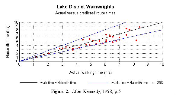
In a study by Kennedy (1998) the ascent time for peaks in two areas were chosen to investigate the reliability of Naismith's Rule; the Lake District 'Wainwrights' and the Munros in the Scottish Highlands. In this study the original Naismith's Rule was applied without Tranter's correction and with no additional allowance made for scrambling routes or steeply descending pitches.
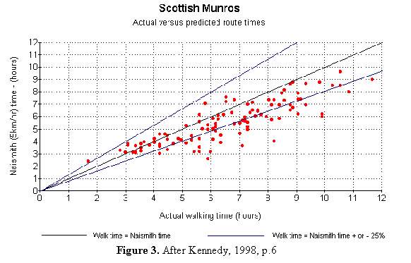
Figure 2 shows that Naismith's Rule is a good predictor for walking time in the Lake District hills within a percentage of 25 percent. On another terrain walking distances may differ significantly. This is the case in the Scottish Munros. Differences occur due to the amount of scrambling required on these routes and the more serious nature of winter routes (most of the points below the lower 25% line are scrambling or winter routes). Furthermore, when walking long distances, a 'fatigue factor' is revealed. This is shown in figure 3.
[Clearly, the Poms take hill walking very seriously! RNC]
If you want to use the Naismith Tranter Rule to calculate your walking times, this reference gives you a web version. I have no idea of it's accuracy under Australian conditions, but it makes for some amusement. Another web site which goes into Naismith's Rules in great detail is due to Gillean . RNC
There are plenty of books on the market about navigation. Some are good, some are 'less good'. Mike Harding in Jan 2004 told me that the government mapping agency Geoscience Australia at http://www.ga.gov.au/ used to do an excellent booklet on this subject. However, I can't find it there anymore. Fortunately I had downloaded it already, so you can get it here from this web site instead.
Maps come in various forms: the most common are the topographical map from a government department and the sketch map drawn by other walkers. The 1:25,000 or 1:50,000 are the two most useful scales for topographical maps. These normally have a contour line every 10 metres. Reading them is mainly a matter of first being taught a bit of interpretation by others, then practice.
A good walker can often visualise the terrain from the contours on the map; an experienced walker can do this and be right (mostly). A really experienced walker can look at a topo map and know what is missing: a talent quite useful with some Blue Mts topo maps which have 20 metre contour lines and miss out on most of the cliffs. The trick with these maps is to assume that every 20 m contour line is probably a cliff. You won't be too far wrong.
|
|
|
For some areas or some special things you may have to use a sketch map. These are becoming a thing of the past, but they used to be very treasured items. The Tasmanian South West was initially explored (60s) with a combination of aerial photos and sketch maps. People walking through there today with topo maps and tracks are just not doing the same thing. Sigh.
When you look at a topo map you will see it is covered with a grid of lines, vertical and horizontal. On the 25k and 50k maps these lines are usually 1 km apart - unless you have a very old map where the lines are 1 mile apart. You can specify a position on the map by quoting the horizontal and them vertical coordinates. A good book on navigation should be consulted for more details (suggestions, anyone?).
Since the map has these lines 1000 metres apart, grid references are usually given to 100 metres in each direction. However, with a good quality map and some care, an experienced navigator should be able to quote a position to within 50 metres. Of course, the whole thing goes out the window if the map is not accurate to that degree, and it is known that some of the Blue Mountains maps are not accurate. There was a lot of trouble when "they" tried to match up the edges of some of the maps covering the Wollemi region. Entertaining. Modern GPS units can quote to 10 metres - this may or not be much use in practice!
Of course, every axis has a zero, or reference point. This is known as the "datum". In Australia we are "fortunate" enough to have a choice of three different datums: AGD66, AGD84 and GDA94. What this really means is that the authorities keep moving the primary reference point! The first two datums differ by only about 5 metres, but the third, which was introduced only in 2001, moves everything by several hundred metres. In addition, NSW, Victoria, Tasmania, and the NT have used AGD66, while SA, Qld, and WA have used AGD84. Why have they changed things? Blame a combination of the introduction of the GPS and previous Australian surveying errors, dating back ... a very long time. They now want to make Australia compatible with the World Grid System (WGS84) so that we match the world standard for GPS units - so we all shift. The differences are small, and really only matter when you are trying to use someone else's grid references off the wrong datum. New maps, post 2001, should feature the new datum.
Two very interesting Australian references on the issue of the grid and the datum are Geoscience Australia: Geodesy - Geodetic Infrastructure - Datums and Intergovernmental Committee on Survey and Mapping - GDA. I found these when trying to answer a question about where the Australian Datum is located. It isn't: we are part of the global grid system. The primary references are Greenwich in the UK and the Equator.
Some walkers are happy to buy maps, use them on trips, and replace them regularly when they get wet or torn or damaged. Others care for their maps lovingly, seldom taking them on trips for fear of damage. Instead they take photocopies which can be replaced. The real problem here is that if you don't look after your map, it may become useless half way through a trip. This can be worrying. Incidentally, if you own the original of the map, you have paid the copyright fee and are legally entitled to make as many photocopies for your own use as you want. If anyone argues, just say "Sony Betamax case" at them. The author is prepared to defend this position. It falls under the heading of "research or fair dealing". Just don't try selling the copies: that breaches copyright. Making a couple of copies of a section of a map for friends on a walk is a bit of grey area. The chances of being prosecuted are about zero. Making twenty copies for a school party seems a bit over the top however.
Generally walkers protect their maps on a trip by putting them in a clear plastic cover of some sort, to keep them out of wind and rain. You can but some little satchels of clear plastic to hang around your neck, or you can put them in plastic sleeves. The latter works well with A4 and A3 photocopies. Alternately, you can buy archival photocopy paper which is totally waterproof: it is actually a sort of plastic paper. A good photocopy (fused toner, not inkjet!) onto this paper will last for years in the rain. Celcast make some of this called "Permanent paper" in sizes PP3 (A3) and PP4 (A4), and Xerox also made some.
Recently (>2000) the NSW topo maps started coming out in a new release or edition. The paper is more glossy, the details are supposed to have been updated, and there is a colour aerial photo of the area on the back surface. All very nice, but some maps do not appear to have been really updated: they still have the same errors on them. Listing all the errors might consume this web site, so we will for now simply repeat the old message that you should not believe everything you read, especially about tracks on maps. Feedback from the field about the paper quality is not so good either. David Springthorpe reports that the new glossy paper frays more easily at the folds than the old paper. Why am I not surprised? It makes even more sense in this case to take photocopies when walking rather than the original.
Andrew Sander replied in aus.bushwalking to a question on digital maps as follows. More information on this would be greatly appreciated. Apparently in America you can get all the standard topo maps off the web for free: their national mapping authority is paid by taxpayer money so the taxpayers are entitled to them. A novel thought for Australia.
You wouldn't be looking at the 250k version 2 geodata from "http://www.ga.gov.au/bin/mapserv36?map=/public/http/www/docs/oracle/geocat/geocat.map&map_gaz_x=0&map_gaz_y=0" by any chance?
These GIS datasets are available as .shp,.e00 and .mif files (Arcinfo export, Arcview shape files and mapinfo file formats). Unless you have the correct software these formats are not generally useful. You can, however, import these layers into (in my case) Oziexplorer as a track file.
Free Viewers for these formats are available from www.esri.com and www.mapinfo.com.au respectively.
andrew dot sander at bigpond dot com
Victorians are rather lucky now (2005): you can download for free custom PDF copies of topo maps of Victoria from the Dept of Sustainability and Environment at (a href="http://www.dse.vic.gov.au">/http://www.dse.vic.gov.au/. Make sure it has all the layers you want though: this can take a few trials. The only problem was that the scale kept changing upwards when i was downloading a collection myelf. Go to the wrong Vic Gov Dept and they want to charge you for the maps - the weird machinations of Government. The free maps go from the SA border up well into NSW. Seems reasonable to me: it's our taxes which pay their salaries.

Every walker should have one of his own, and should learn how to use it to orient a map. Once your map is oriented you can (usually) work out where you are and where to go next. There are more sophisticated things you can do with compasses like taking bearings and triangulating your position, but usually it just isn't necessary.
Let's be very blunt about this: if you cannot use a map and compass in the bush you are not a competent bushwalker.
If you have always let someone else look after the navigation, you are not a competent bushwalker, just a follower.
You will find quite a range of quite large, complex and very expensive compasses in the bushwalking shops. The heaviest is the brass army WW2 'prismatic' compass, accurate to a small fraction of a degree. You simply don't need anything like this. Then there is a whole range in luxury down to the simplest little protractor compass you can stick in your pocket. The prices seem to vary with size and frills. This is one of the places where "ygwypf" breaks down. Economics intrudes: there is more profit margin on a big expensive compass than on a little cheap one, so it is in the vendors interests to promote large expensive ones.
As a general rule, the bigger, more expensive, and heavier the compass, the more novice the walker.
In more detail, what you need is a small simple compass which meets most of the following criteria (and looks a bit like the picture here). That said, I used an even simpler one in Spain: just a round oil-filled unit. I bought it in a newspaper shop after I lost my original one somehow. I thought about replacing it when we got back, but never bothered. It meets almost all the following criteria, and suffices to navigate through Wollemi.
There are some non-requirements as well, although doubtless some walkers will disagree with these comments. For a start, you won't need a "glow-in-the-dark" coating on the compass needle. If you need to navigate in the dark, you will need to see the map as well, and that means a torch. Only endurance racers will be travelling cross-country in the middle of the night by compass (or by stars) on a memorised course. In this case, the stars are probably better. Unless it is raining . . .
Some compasses have scales down the sides. You will note that the compass in the picture above has lost the scales: they were rubbed off ages ago. They are not really needed: you can estimate tenths of a grid pretty easily, and so what if you are slightly wrong in the field? What normally matters is where you are and what direction you are going in, not exactly what grid reference you are at.
 Some compasses have "sighting" arrangements on them: either prisms or mirrors or whatever. These are sometimes called mirror or prismatic compasses, rather than "protractor" compasses. Most times in the Australia bush you won't need one of these because you won't get long views of distant peaks: we have too much scrub and not enough pointy mountains. Anyhow, if you have travelled so far without monitoring your position that you need to sight off distant mountains to work out where you are, you will probably have trouble even identifying which of our rounded hills are which! And the distant mountain may not even be on your map. Note also that many of these sighting compasses do not have the facility for offsetting the magnetic declination, which can lead to all sorts of errors when you add the declination instead of subtracting it!.
The map to the left shows declination around the world: clearly it is not a simple thing - and it is changing with time too. You should find the rate of change on the topo map: if the map is old it may be a good idea to do the maths to update the declination to a best guess at the current value. Good Luck.
Once you have a compass, and have corrected it for the magnetic declination as shown on the edge of any topo map, practice orienting your map. Put the compass on the map with the compass edge parallel to the grid lines on the map, and then rotate the lot until the needle aligns with the N-S lines in the compass. Fairly soon you will be able to match up the ridges and valleys shown on the map with what is in front of you. This is known as "visualising the contours". This assumes you are where you think you are, of course! The next lesson, which immediately follows this one, is learning what to do when you think the topo is wrong, or it doesn't quite match the terrain around you. All experienced bushwalkers have met this problem many times: we keep saying "the map must be wrong", while knowing damn well that the reality is we are not where we thought we were. Handling this comes with experience. And experience comes from making this mistake ... repeatedly ...

Every now and then someone asks whether the compass they have bought in the Southern Hemisphere will work in the Northern Hemisphere. The short answer was going to be "yes, despite learned comments to the contrary from those who have not tried it". The author and others have used many Australian compasses in the UK, and UK compasses in Australia, both with no problems. However, reports from other readers such as David Morrison spell out some problems, experienced first hand. We will go through 'what should be' first, then discuss what David reports.
The theory behind the question is as follows. The Earth behaves as a huge bar magnet, with the magnetic field going from the S pole to the N pole. Get a book on navigation or whatever to see exactly what it will look like. A very rough illustration of it is given to the right: be warned it is not very accurate. In fact, as we shall see below, it is not at all that simple! Anyhow, the critical thing is that around Sydney or Melbourne (say) the magnetic field is not horizontal: it tilts down towards the S, while in Europe (say) the field tilts down to the N. This means the compass needle should really tilt, with the N end pointing up in the air in Australia and downwards in the UK. But when you look at your compass needle in the bush you see that it is pretty much horizontal. Therefore, the theory is, the needle must have a weight on the N end to balance the tilt in the Australian magnetic field. The (il)logical consequence is that the compass you buy in Australia should not work in Europe.

If you really want the technical details about this, then 'Main Field Inclination' is a good search phrase. It is also referred to more simply as 'tilt'. A map of this is shown here, taken with acknowledgement from http://ngdc.noaa.gov/geomag/WMM/data/wmm-I05.pdf . The tilt in the region of Sydney, Australia is about 64 degrees - a startling amount. And yet, our compasses manage to handle this. Which is more than most digital wrist watches manage, by the way. The magnetic compasses you find on most machismo watches work - until you tilt them more than a degree or two away from the horizontal. Then they go haywire.
Fortunately this theory is all wrong for some of the simple protractor compasses, as many people who have taken their simple protractor compass from Australia to Europe or vice versa will tell you. Their nice little compass worked just fine on either side of the equator. The warnings from 'experts' and vendors that you need to buy another compass were obviously wrong - for them. Why is this so? (Note that ultra-precision compasses may be slightly different, but you don't take them bushwalking!)
The fault in the previous logic is the assumption that the needle has to be weighted at one end to remain horizontal. This is not strictly true. The force available to tilt the needle is less than the force available to rotate the needle, and the magnetic force is fairly small to start with. It does not take much force to rotate the needle on the bearing to point north after all. But there is another much larger force coming into play - gravity, which can be cleverly combined with some neat engineering of the pivot, to produce what is often termed a 'global compass'.

Your compass consists of a long thin needle pivoting on a pin with a fine point: the bearing. If you look closely at the centre of the needle you will see a little cylinder, and the top of this cylinder is usually well above the plane of the needle. There is very hard surface inside this cylinder at the top: a jewel bearing in all the better brands of compasses. A hardened steel pin sticks up inside the cylinder and supports the needle via the bearing or pivot point at the top. In addition, there may be a metal ring under the needle, labelled 'lower weight' in the figure. One reason for this ring is to stop the needle tilting very far when hanging around your neck, but that can be done with a very light ring. Sometimes it seems a much heavier ring is used, and this is one way of producing a 'global compass'. All this is shown in the figure here for a typical protractor compass.
Now consider the needle as a balance arm. The centre of support (the tip of the pin) is typically about 2 mm above the plane of the needle. If you have that 'heavy' metal ring below the needle, the Centre of Gravity (CoG) will end up some distance below the plane of the needle. In effect, the mass of the needle is hanging 'down'. As mentioned above, the torque aligning the needle in the N-S direction is quite small; the torque due to the tilted magnetic field is even smaller. In these sorts of global compasses the needle tilts maybe a degree or two before the effect of gravity balances things out. (Yes, I have measured this on three of my own compasses.) Given the normal use in the field, I doubt anyone would ever be really conscious of this small tilt.
In addition, the bottom entry to the metal ring has only a small hole in it. If you tilt the compass right over the needle will attempt to stay horizontal - until the support pin touches the side of the ring. Then the load goes on the side of the pin and the ring, and off the pivot bearing. When the compass is really tilted, or upside down, the lid on the compass chamber keeps the needle from falling off the pin. Of course, under any of these conditions the needle is not going to rotate much, so it may be pointing anywhere. The moral is to keep your compass level when you are using it, and make sure it swings freely.

Even some otherwise good compass makers apparently produce compasses with either no lower metal ring or a very light one, such that the CoG is very close to the tip of the support pin. As a result, the needle becomes much more sensitive to any tilt in the earth's magnetic field. Such a compass needs a counterweight to function anywhere except near the equator. Once a counterweight is installed the compass depends on the tilt it was designed for, and if you switch hemispheres, or even 'zones', you will be in trouble. The 'zones' of the world for Suunto compasses are shown in the diagram to the right. This diagram is copied from the Suunto web site with acknowledgment. According to Suunto, straying outside the correct zone is not recommended; going more than one zone away stops the compass from working. However, even those zones do not show that when you are really near the poles things will still stop working. When you are right at the North Magnetic Pole the Earth's magnetic field goes vertical. Could be a trifle difficult there!

The situation is actually much worse than depicted above. The Earth's magnetic field is not a simple bar-magnet dipole as shown before. It is a horribly complex scrambled mess inside the core of the planet, and this is reflected in the magnetic field seen at the Earth's surface. The magnetic flux lines go all over the place: we are lucky to be able to use a compass at all! The diagram to the left shows the polarity of the Earth's magnetic field around the surface of the planet: there are all sorts of deviations visible. (This is basically a coloured version of the map of Tilt shown above - the colour makes it easier to read.) The variations in tilt are actually partly reflected in the Suunto region map above. The complexity is due to the confused swirling mass of molten iron inside our planet which gives rise to the magnetic field: there is a lot of turbulence and the magnetic field gets a bit scrambled at times. A simple dipole it is not. In fact, it gets so scrambled that at times the N and S poles wander all around the place, even reversing their positions. This has happened countless times in Earth's history, as shown in the time chart below.

What is a bit of a worry is that over the last 20 years or so some new variations in the field have been detected, as shown by the arrows in the 'NE' corner of the picture to the left with the label 'New Patches': the magnetic field at these places has actually reversed in the last 20 years. If a full dipole reversal were to happen today you could just about throw away your compass for the next thousand years, until the chaos deep down under had sorted itself out. Maybe we would all have to use a GPS for navigation then!
David Morrison reported that his (bought-in-Australia)) Suunto A-2000 perspex orienteering compass showed the problem of needle tilt in the UK. He had to tilt it about 20 degrees to free the needle each time. It was obviously a problem for him, to the extent that he added "I hardly ever used the compass because of it."
The web sites of some compass manufacturers mention this problem, with some of them adding that 'global' versions of some of their compasses are now available. I think these 'global' versions have a more complex multiple-bearing system inside them. However, many of these 'multi-bearing-global' compasses are very expensive. They tend to be larger and heavier as well. My summary is that they are simply not necessary for bushwalking.
Two things should be said here. The first is that many of the cheap/simple protractor compasses I have seen in Australian bushwalking shops appear to be of the more simple 'what-I-call-global' variety. Many of us know from experience that our simple compasses do work around the world. Given the propensity of Australians to wander around the world, this is a very good thing. It may also indicate some intelligence on the part of some importers - but check before you buy! The second is that adding the necessary lower weight to a compass needle to make it function as a simple global compass does not have to make it any less accurate or sensitive, or any dearer. Modern steels and engineering techniques are quite capable of producing top quality global compasses: do not settle for anything less! Frankly, I cannot see a single reason why anyone should bother with one of the more expensive non-global versions, let alone the expensive 'multi-bearing global' versions offered (unless you like throwing your money away).
None of this is much use to you if your compass is one of the more expensive ones which is designed solely for one particular zone. In this case bite the bullet and buy a small cheap protractor compass. You may find it is smaller, easier to use and carries a lower weight as well. By way of reference, I had to buy a new compass in France in 2004 - I had lost my current compass when I took my shirt off and dislodged the string around my neck. I bought the simplest, cheapest oil-filled compass I could find, for a just few dollars, in a newsagency. I still use it for all our navigation here in Australia. It finally started to die in 2009, when the seal in it leaked a bit and it developed air bubbles. But i was going from 300 m to 3000 m on a very regular basis for a while.
A GPS unit uses radio signals from a number of satellites to tell you (almost) exactly where you are. If you haven't the faintest idea of where you are, a GPS unit may be able to tell you - always provided you have adequate reception of the signals and the GPS doesn't get itself confused. Unfortunately, both do happen (see below). Let's assume it works and you wait the time needed to get an accurate position. Then what? How do you get home? You still have to be able to navigate, which means reading the map and understanding the terrain.
Many experienced walkers still haven't bought a GPS: they just don't think they are necessary where they walk. Indeed, they are not necessary: generations of walkers managed just fine without them. This doesn't mean you shouldn't have a GPS in the bottom of your pack, "just in case". That's fine; just remember they cost money, add weight, and the batteries run out at awkward times. It's your decision.
Which GPS should you buy if you really want one? When I wrote this in 2002 I did not have a GPS unit. The units available then were a bit primitive and anyhow, I can navigate quite well enough with a map and compass. More recently (December 2002) I succumbed and bought a Garmin eTrex-H. Not, I hasten to add, for ordinary navigation but to assist with some mapping work in some tricky country. I have to say the performance of the eTrex-H, with the new SiRFStar III chipset, seems to be much improved over the older models. I tested a locator which contained an older GPS chipset and found that it could not get a lock while it was moving, even under a clear sky. The eTrex-H, the cheapest of the latest generation (no mapping function), is noticeably better than that.
There are Usenet news groups such as sci.geo.satellite-nav (thanks to Steve Reynolds) and sites like www.gpsoz.com.au dedicated to the GPS, and these are good places to look for more answers. Some advice is given below, and maybe we will get an FAQ page specially for GPS and EPIRB units later.
There are a few places where a GPS would be useful. In the Australian outback, where there are untold kilometres of sand and desert and little to navigate by, a GPS could be quite useful. This would apply whether you are walking or driving. And in some areas of flat forested bushland which are laced by logging tracks and fire trails, not all of which are on the topo, a GPS could be very handy at times. It has been reported (by many walkers) that some topo maps show 4WD tracks where there are none, while missing tracks that are there. Oh yes: a GPS can be useful!
It has also been suggested that all school/youth groups should carry a GPS. Given the number of times these groups figure in Search and Rescue, this may be a good idea. However, by themselves they will not save anyone.
Owners report that a set of batteries should last for about 8-12 hours in a modern GPS unit, depending on the model and the battery type.
I am not an expert on software to work with a PC, but I must say I found EasyGPS to be remarkably easy to install and use to connect my GPS with my PC. Configuring the fine details was also very easy. It has the huge advantage of being FREEWARE too!
I would like to find a simple freeware conversion utility which can convert between degrees and a map grid such as UTM. If you know of one, please let me know.
Mike Harding suggested a couple of useful web sites for GPS information:
"This site is very good for all things GPS http://gpsinformation.net/
This site tells you how it all works - bit technical http://www.edu-observatory.org/gps/gps.html
And this one gives you more info and conversions tools for GPS and maps http://www.maptools.com/."
Dennis Shubitowski reported (via BackpackGearTest) the following Yahoo groups concerned with GPS (mainly Magellan):
http://groups.yahoo.com/group/magellan-gps-users/
http://groups.yahoo.com/group/magellan_sportrak/
http://groups.yahoo.com/group/sportrakgps/
http://groups.yahoo.com/group/map_authors/
http://groups.yahoo.com/group/mobilemapper/
In addition, I have had good service from a guy called Brian at www.gpsoz.com.au. He was able to sell me some plugs to fit the Garmin and to recommend some programs to use on a PC with the Garmin. He is a member of a strange organisation called pFranc, which sells all sorts of plugs for GPS units on a 'ship now pay later' basis.
Anthony Dunk wrote for this FAQ:
What is GPS?
GPS stands for Global Positioning System. It was created by the US Department of Defence and uses a constellation of satellites to transmit position fixing signals. Users can receive these signals with a hand-held GPS unit and accurately determine their position on the surface of the earth.
What is Selective Availability (or SA)?
When GPS was first introduced the civilian signals were intentionally degraded to reduce their usefulness to users other than the US military. This was called Selective Availability or SA. SA meant that the public could only receive GPS signals with an accuracy of about 100 metres.
On 1st May 2000, SA was turned off. GPS users could then receive signals with an accuracy of about 10 metres. The US is committed to leaving SA turned off, but now has the ability to turn GPS signals off on a regional basis when its national security is threatened.
What GPS should I buy?
There are many makes and models of GPS to choose from. Garmin and Magellan are amongst the better known brands. When choosing a GPS for bushwalking you should consider battery life, size, weight, waterproofness, ruggedness, and the ability to down-load your recorded positions to a computer.
Additional features which may be of use to some users are an external aerial (for use under heavy vegetation cover such as rainforest), and the ability to up-load data from a computer and display maps on the GPS screen.
What are the limitations of GPS?
GPS units need to be able to see at least 3 or 4 GPS satellites to get a fix on your position. This means that they need a clear view of the sky. In narrow canyons or under heavy rainforest vegetation it may be difficult to get an accurate position. [See also the next contribution - RNC.]
Is a GPS a replacement for the compass?
Although it is possible to navigate with GPS alone, it is not recommended. (Privately, I think it is a stupid concept, but I am biased.) Compasses cost a fraction of the cost of a GPS and are inherently more reliable. Compasses do not require batteries and do not need to have a view of the sky to work. A map and compass covers a huge area compared to what you can get on the miniscule screen of a GPS.
What map datum should I use?
It is important to set your GPS unit up to use the same map datum as the maps that you use for navigation. Most GPS units have a menu of supported map datums. Once the correct datum is selected, the GPS should display grid references which you can use to read your position directly off a topographic map.
Older Australian maps use either the AGD66 or AGD84 datum. These two datums differ by only about 5 metres. NSW, Victoria, Tasmania, and the NT use AGD66. SA, Qld, and WA use AGD84. New Australian maps use GDA94 (Geocentric Datum of Australia). This new datum was introduced to bring our maps in line with the World Grid System (WGS84) so that they are more easily used with GPS units. AGD66/AGD84 positions and GDA94 positions differ by about 200 metres. Formulas for converting between these two datums are available on the AUSLIG web site (www.auslig.gov.au).
New Zealand uses its own map datum, NZMG. This is not compatible with the Australian map datums. However, New Zealand plans to introduce a geocentric datum similar to Australia's new datum in the future.
David Moss (a member of Bushwalkers S&R) had this to say about the use of a GPS:
Never Blindly Trust a GPS
If it has determined the correct position solution, it will return a very accurate location. If it has not, it will tell you very precisely where you are not.I have two 'reference examples' - both with different model Garmin GPS receivers, where as part of acquiring a position solution, an incorrect location (tens or hundreds of km away) has been determined. The GPS receivers then happily discarded any new satellites that appeared (I guess there are sanity checks in the position solution that assume if a different result is returned then the satellite must be wrong). This seems to happen when only 3 satellites are visible and a 2D solution is generated. 2D solutions are another trap for young players too - putting the wrong altitude into the GPS can put you hundreds of metres off on the ground.
Granted, in both these cases the GPS units were in moving vehicles, but I did travel from Blaxland to Mount Boyce one day with a totally wrong location shown. I wish I had kept the track to prove it. With this one, the solution persisted until I explicitly told the GPS where I was (using my conventional navigation skills and a map), even when the unit was power cycled.
This would be scary in the case of the 406MHz EPIRB with GPS - and the sender would never know. (I assume that the GPS units in these EPIRBS have to do a 'cold start' and acquire the satellite almanacs when powered on. That can take up to 15 minutes worst case). The technology was designed for use in 'wide open spaces' (ie: oceans) where GPS satellite visibility is far better than in dense forests.
Another walker suggested that believers in GPS units should try the following exercise. I would be interested in hearing of any confirmation from other walkers. He turned his GPS unit on to track his position as he walked along a fire trail one day, and saved the log. The next day he repeated the exercise. Then he compared the two tracks, and found they consistently differed by about one hundred metres. The claimed accuracy of a GPS unit today, with Selective Availability turned off, is meant to be about 10m. This was not a single reading but a whole track, so one wonders what was happening.
Andrew Priest (Andrew at aushiker dot com) wrote: "An article entitled 'How to Read the Universal Transverse Mercator (UTM) Grid' from GPS World, April 1996 has been 'published' online at http://www.nps.gov/prwi/readutm.htm. Looks like a useful article for anyone using a GPS". Mike Harding also recommended it.
Mark wrote "I have a PDF file that will print off a UTM grid that works really well on 7.5 min quads (use Mylar sheets in your printer). I'll post it or email it if anyone is interested."
GPS units often work in Latitude and Longitude, although most can be switched to other units. But sometimes you want to convert between the two. Several means exist, as reported by various readers, including punching the values into a GPS unit.
Glen Fergus
Andrew Sander
Phil Wyatt
It is possible to travel across country accurately without a compass, by day or by night, and it can be fun. You can use the position of the sun or the stars, or even recognisable mountain tops.
In the daytime you can navigate fairly accurately with a watch. You point the 12 o'clock direction of the watch at the sun and North is then halfway between the 12 and the hour hand. So at midday the sun is to the North, and at 6am the sun is to the East. That's the simple theory, and only half right. You have to allow for any daylight saving corrections of course. Less obvious is the fact that we have a fixed time across wide areas of Australia: on the East coast it is called Eastern Standard Time. The consequence of this is as follows. It can be the same "time" at Sydney as at Broken Hill, but North will be in a slightly different direction relative to your watch because the sun will be at a different position at the two locations. It means the North you find this way is not very accurate. However, plenty of experienced walkers can orient a map accurately enough by the sun that they can then identify landmarks. Doing it without a watch is slightly more difficult: you have to use the height of the sun above the horizon to estimate the time of day. But that isn't all that hard either.
By night you have two excellent guides to follow. The Southern Cross points to the South Celestial Pole, as does the line bisecting the distance between the Pointers. If you can only see one of these you can still estimate the position of the SCP from geometry, but this requires a diagram or a photo of the stars. Maybe someone can provide a diagram or a photo?
The stars do provide quite accurate navigation. I did this once for training in the Boy Scouts: the incentive was the dinner waiting in the dark at the other end. There was a clear sky and a full moon that night as we were dropped off, each at his own starting point. The tricky bit was the fact that they took our maps away before we started: we had to run on memory and pre-calculated bearings. Half way along I realised I had not allowed for the magnetic declination on the map, and had to mentally do a correction. Nonetheless, over a distance of about 5 km, at night, without map or compass, most of us came out close enough. We got dinner.
Of recent times it has become possible to integrate an electronic altimeter into a large wrist watch. They are not cheap, and few Australian walkers will have had much experience with these in Australia. However, altimeters are regarded as useful or even essential tools of navigation in the mountains of Europe. The author acquired a watch/altimeter as part of a BackpackgearTest trial, and quickly found it quite handy. That is not to say it is magic however.
The first things to remember when using an altimeter is that it is only approximate! It relies on measuring the air pressure to calculate altitude. Now altitude and air pressure are related: and increase in altitude of 25 metres gives a drop in pressure (at least around sea level) of about 3 hPa. But you can also see changes in air pressure of 10 hPa quite easily. This means that an altimeter can easily be out by 75-100 metres, depending on the weather. In addition, there is a diurnal pressure fluctuation of about 3 hPa total: lower in daytime, higher at night. However, you can always correct for local sea level if you know a few spot heights. So, to get the best results, you need to monitor the readings against the topo and either reset the 'zero' on the altimeter regularly - even several times a day in variable weather, or at least to remember a correction factor such as 'the altimeter is currently reading 60 m too high'.
These days it is possible to carry a small electronic transmitter called an EPIRB. It is a radio beacon which can be activated under life-threatening circumstances to call for help. They are compulsory on any boat going more than a certain distance off-shore. They can give your location in one of two ways: by direct analysis of the signal received by the satellites used for this, and by having a GPS unit in the EPIRB. However, they are not for use when you are just tired or hungry and want to go home. Should you carry one?
Some contributions seen on aus.bushwalking over the years are listed below:
EPIRB Hire
Steve Cooke reports that you can hire EPIRBs in Tasmania via http://www.parks.tas.gov.au/recreation/epirbs/epirbs.html.
EPIRB Costs
"I work for Qld Fire and Rescue Authority and I raise accounts for searches for EPIRB signals all the time. It generally costs about $3800 per hour. Usually the Aust Maritime Safety Authority gets billed even if it is for a missing walker, although there have been instances where Nationals Parks and Wildlife are billed."
So inappropriate triggering of an EPIRB may result in you getting the bill, but see also below.
EPIRB Trials
"Just had an interesting day helping conduct the first live sanctioned testing of EPIRBS in Australia. Today and over the next week live testing of EPIRBS will be carried out in the Lamington Park area.
The group consisted of a representative from Police Rescue, National Parks and Wildlife, Aust. Search and Rescue, Federation of Mountain Rescue, EPIRB manufacturer representative and a group of bushwalkers from local clubs to do the legwork and navigation.
Today's walk was on an easy graded track out from O'Reillys and we [bushwalkers] didn't really do much except say..."yep, this is typical rainforest cover etc".
We had three times that we knew when the satellite was passing overhead and it was our job to be at the 3 designated points at those times. If we didn't make it to those points the EPIRBS would be set off irregardless.The officials had with them..
2 Satellite phones
3 GPS units
3 EPIRB units. They consisted of the basic 121.5 MHz model punching out 0.5 watt, the new 406 MHz standard and a 406 MHz model with a built in GPS and 5 watt of powerBasic [EPIRB] unit is about $300, 406 unit about $2,000 and an extra $400 for the GPS. The GPS cannot be accessed or read off the unit, it only transmits. The read function is not available because the unit must be guaranteed to transmit for 24 hours and if people used it as a GPS they would flatten the batteries.
The first test was at 10:30 am with the units being left on for 15 minutes. Each unit was turned on at 5 minutes interval. The area was on the side of a slope under medium to heavy rainforest cover on a warm dry day.
Only one GPS unit managed to get a weak signal (the police Magellan 3000XL) and gave a location of 28.14.08 S, 153.08.39 E. Only one sat phone got a weak signal. The phone looked like a small laptop and had 'one bar' reception showing (with 5 being good). The phone call got bounced down to Perth and then back to Canberra who we informed the test was about to begin.
The 406 MHz units have a 2 minute start-up feature where you can turn them off without a signal going off.
After the test we made another call to Canberra who informed us that the first 406 MHz unit got through OK, the second unit took a little longer to process with no GPS signal and the 121.5 MHz unit didn't get through. The location of the 406 MHz unit was very poor and was out about 12 nautical miles. Both units where identified as separate signals and the registration details where known. No commercial planes reported the signal but a light plane did fly directly overhead.
The second test was at 1:00 pm in a creek. Overhead was clear with a moderate gully slope and medium rainforest cover. Both sat phones got out OK, but still only one GPS worked with a fair signal. Our location was 28.14.04 S, 153.08.41 E. The second test was 5 minutes longer to see if the satellite could process the GPS signal.
All 3 EPIRBS got picked up but NO GPS signal. We still got a good positioning reading off the satellite using the Doppler Effect that put us within one nautical mile of our handheld GPS unit
All the GPS units hardly worked all day with very faint signals at best. The GPS unit built into the EPIRB must use the same satellites and triangulations as the handheld GPSs. It is a different satellite that receives the EPIRB distress signal but located us using Doppler Effect.. No commercial aircraft reported us. This would be primarily because the units where only on for 15 minutes.
Just because the 121.5 MHz model wasn't picked up on the first test didn't mean it wasn't working. If we left it on all day sooner or later a plane would have picked it up."
John Henderson (who was involved in setting up some of the EPIRB system in Australia) wrote on 17-Aug-03:
The newer 406 MHz technology has been up and running from day one in Australia (over 14 years) - mainly for marine use, but increasingly for personal and (especially) aviation use.
406 MHz beacons are specifically designed for satellite detection, and offer many advantages. They are digital, and transmit identifying data. This allows a registered contact to provide additional information when one is detected. They also have tighter tolerances for frequency drift. This enables them to be electronically located with much greater accuracy, but adds considerably to the cost.
I would not consider buying a 406 unit for personal use at this time. But a 121.5 MHz unit is very highly recommended for long-distance solo walkers. I find my walks much more enjoyable when I don't have to worry so much about the consequences of about tripping and breaking a leg, etc. (it happened to a friend of mine once - wasn't found for about 4 days, luckily he was next to a running creek).
A protracted Australian campaign to allow a cheaper version (less accurate) of the 406 MHz technology has finally succeeded. These may be available next year.
Satellite detection of 121.5 MHz EPIRBs is very likely to cease, on schedule, in 2009. But 121.5 MHz will remain the civil aviation international distress frequency. So these will still be detected (and responded to) where planes fly.
Lucas Trihey from Outdoor Magazine wrote on 26-Aug-2003:
The Australian Maritime Safety Authority (AMSA) is the federal government authority that oversees search responses to distress beacon activations in Australia. AMSA have just advised of two announcements regarding PLB/EPIRB use and Ground-to-air visual distress signals. AMSA are unable to make contributions to this group (although they do view the group discussions from time to time) and have asked me to alert this group to these announcements.Please check this website for current details of PLB/EPIRB use: http://www.amsa.gov.au/beacons/Headlines/Bushwalkers_PLBs.asp
And this site for details of Ground-to-air visual distress signals: http://www.amsa.gov.au/natsar/Ground_to_Air_Emergency_Code.aspThe Outdoor Australia website (http://www.outdooraustralia.com) also has links to both sites and will carry other updates on distress beacon use in future.
On a more general note, a reader contributed this page on EPIRBs which he had prepared for his Brisbane walking club. I have converted his neat pdf into html: I hope it has survived. However, to my embarrassment I have lost his name. Please help.
1. Using an EPIRB
- Carry an EPRIB
- Switch it on when you have a serious problem
- Don’t switch it off
- Know your first aid
- Prepare your search and rescue plan
2. If you can’t walk out, then you need a rescue.
Australia has a network of search and rescue organisations. They are very happy to rescue people from life-threatening situations. That’s their job. Use them! Here are some examples of situations where you can’t walk out, and you need to be rescued:
- Sprained ankle. The amount of medical attention required may be minimal, but the patient cannot walk and must be evacuated to prevent life-threatening exposure.
- Snake Bite. The patient requires urgent medical attention, and should not walk.
- (Suspected) heart attack. The patient should not walk, and requires urgent medical attention.
- Broken bones. The patient should not walk, requires medical attention, and there may be further undiagnosed injuries.
- Party is Lost. If you don’t know where you are, then you can’t walk out safely.
- One party member is lost. If you have lost a member of your party, you will need some help with the search and rescue.
- Flood-bound. If it is not safe to cross the river, then call for a rescue.
If you are reasonably sure that you (and your party) can walk out without assistance, then do so. These situations would probably not warrant calling in a rescue:
- Car trouble. You can walk 20 km to find a phone and call RACQ. This may make you late home, but is not life-threatening.
- Blisters. Blisters can be uncomfortable, but probably not life-threatening.
- Late home. If your party is late home, but safe and well, then you don’t really have an emergency. However, concerned relatives may have started a search for you. If you see the helicopter searching, it might be well to activate your beacon to hasten the end of the search.
3. If you need a rescue, then use the EPIRB
If you have determined that you need a rescue, then the EPIRB is the best way to get it.
- You don’t have to wait very long. The signal is detected quickly, and you may have paramedics with you in 60–90 minutes.
- It is very cost effective. An EPIRB rescue avoids the expensive “search” phase because the satellites and helicopters can home in on the beacon.
4. How to use the EPIRB.
If medical attention is required, switch it on straight away. Don’t wait for morning, don’t wait for good weather, don’t wait for the injury to heal or get worse. (If conditions are not good for a helicopter rescue, then emergency teams will be dispatched on foot, boat, ski-doo etc, as appropriate.) If the situation is not particularly urgent, such as a party lost but sufficient food and shelter for the night, then it may be best to activate the beacon in daylight. Carry your EPIRB instructions with your EPIRB. Read them. Being on a ridge is better than in a gorge. If it is easy to do so, then move the beacon to a place where plenty of sky is visible. Use your space blanket to amplify the signal. Spread the blanket on the ground, and place the EPIRB on top, with antenna pointing up. The EPIRB signal will work through forest canopy, but the pilot may have difficulty seeing you, and difficulty winching. A clear spot is preferable if it is easy to find. Make some other signals. (Remember how hard it is to see through the trees when you look down from a lookout.) A smoky fire can be seen and even smelled by air crew pilot. At night, a fire may show up on infra-red detectors. Use flashing lights, mirrors, etc. A bright red or yellow rain coat or ground sheet may be easier to see. If you can see the aircraft, move so you are not under the leaves, and wave your arms (and hat and torch) in a large sweeping motion. Leave the EPIRB on. Leave it on when you see the aircraft. Leave it on at night. Leave it on until the rescuer tells you to turn it off. If you have a mobile phone, you might get some coverage at the top of the nearby ridge. Phone 000, and say
- EPIRB beacon activated
- nature of emergency
- your name
- your location
- Your Bushwalking Club contact officer phone number (if applicable)
- If the phone is locked, or out of service range, you could try calling 112 instead of 000. This magic number should work on all GSM phones, in all countries, on all networks, without needing a SIM and without unlocking the phone.
5. How will emergency services respond to the EPIRB signal?
The signal is first detected by satellites, and the information is relayed to Canberra. The position given by the satellite is not very accurate, maybe 50km, but is often sufficiently accurate to know which helicopter to call. Commercial aircraft are also listening for the signal and will relay the information to Canberra. The control centre may decide to wait for a second satellite pass. This gives confirmation that the signal is not an accident, and better accuracy in the location. This may take another 15 minutes.
The appropriate resources are dispatched to respond to the beacon. In the case of south-east Queensland bush, this will likely be Energex Community Rescue at Sunshine Coast, Queensland Rescue at Brisbane, or RACQ Careflight at Gold Coast. It is possible that other resources will be used, such as fixed wing aircraft, police, state emergency service walkers, Federation of Mountain Rescue, etc.
The helicopter may require 30 minutes before taking off to load the appropriate crew and equipment, and then 30 minutes to fly to the area. There could be a longer delay if the helicopter is already in use on another task. The helicopter pilot will be given the approximate position from Canberra, and will use an on-board homing system to find the beacon. This will take up to 15 minutes. Sometimes the signal bounces of rock faces, causing a little confusion and delay. (You can help by providing other visual signals.)
It is unlikely that the helicopter will land in the bush. It is more likely that a paramedic or Rescue Crew Officer will be winched to the ground. The paramedic will be able to select the appropriate next step, which may involve winching the injured person to the aircraft. At night, the pilot may decide not to conduct the rescue from the aircraft, but can still locate the beacon and co-ordinate a ground rescue.
6. What Rescuers Like
- Walkers who know first aid.
- Good contact information left with friends.
- Being guided straight to the spot by a beacon.
- Assisting people in difficulty to happy outcomes.
7. What Rescuers Hate
- Walkers who have made no attempt to prepare themselves for the trip.
- Spending many hours and dollars in the search.
- Arriving too late, and recovering a corpse.
- Beacons that have been activated, and then turned off.
What all this means is that there is a good EPIRB system in place, but it is not meant for really rugged country with heavy tree cover. Having an EPIRB is no guarantee that you will be rescued (although the odds may be fairly good). In fact, you won't even know if your signal has been received. If the weather is foul you have no guarantee that anyone will be able to come looking for you for several days, even if they hear you. An EPIRB may be useful in some circumstances of course. Solo walkers are receptive to the idea, and this may be a good idea. Walkers way out in the outback may also decide the weight is justified, and an EPIRB should work very well out there. Some people carry on about how irresponsible it is to not carry one (and a GPS, and a mobile phone) - but none of our predecessors ever had such things. Few experienced walkers bother carrying any of them. But ultimately, you must make your own choice.
There are two major possibilities here. The first is that you really don't know where you are; the second is that someone is injured. For the latter you will need help, and this is covered below. For the former, there are ways of sorting things out. There is going to be some feature around which is unmistakable. It could be a mountain, a major river or river junction, or even a road of some sort. Start heading in that general direction, and keep checking things around you. Keep asking 'what if'. There are (distressingly) very few areas in Australia which are so far from a road that you can't 'get out' within a day or so - assuming a moderately intelligent choice of direction.
OK, despite your very best efforts, you still don't know where you are, or maybe someone in the party is injured and can't travel. You are overdue, don't have an EPIRB or a mobile phone, but just maybe, if you told someone where you were going and when you should be back, they might send the Search & Rescue to look for you. What should you do?
In fact, very little. Get to a position where you can be seen from the air and stay there. It will help significantly if you can find an open area where you can be seen from the air of course. Do NOT go running around! If you do see any planes or helicopters around, or hear any 4WD vehicles gunning along, a smoky fire is excellent for attracting attention. It also helps to spread a large area of coloured cloth on the ground: an ideal justification for a bright pink sleeping bag liner! If the planes are around in the evening they will be looking for lights: a fire, a torch, or even the flash from a camera pointed at the plane. The latter is very powerful and can be seen for some distance.
A standard quiz asks which few items from a big list are the most useful things to have when you are lost. Not everyone realises that water is the highest priority. After that go for some form of shelter, from sun or rain as appropriate, and then a means of making a smoky fire. And wait.
Contributions
Information on GPS units, EPIRBs and good books on navigation would be welcome.
© Roger Caffin 1/3/2002, 10/1/2010