Selected President's reports will be introduced here shortly.
Some of our interesting hisorical walks are included and more may be added on request.
Current walks are not normally included here; join the club and receive the
newsletter for current walks reports.
Photos are included within the maps.
Some additional walks which are not included in the club news magazine
have been included here.
The yellow position markers contain photographs Mapping and photos by Google MyMaps. Imagery by TerraMetrics and others acknowledged within the map. Track data generated with OziExplorer.
2021 Feb 9 - Queens link exploratory. By David Hardie Solo.
Here is a temporary report of an exploratory on Buxton Plateau to Sharp Peak, Queens Link, Titanic Rock and Blue Gum Creek.
This exploratory was conducted on 9 February 2021 solo with some safety precautions:
1. Exact details of the planned route were left with a responsible neighbour with instructions to advise Robert Sloss and Malcolm Hughes if I had not returned by 6 pm. Both of these members know the locations of the tracks.
2. If I'm incapacitated in any way, then I will able to stay out for a night or two.
3. The functionality of my PLB (Personal Locator Beacon) had been recently checked but I had left the generic search parameters as the Southern Highlands and Nattai River area. Mobile phones only receive patchy service along the Blue Gum Creek.
4. Long trousers were worn and gaiters carried in spite of the hot day. 5. I rarely use a walking stick in the bush but I carried one today for the anticipated difficulty of the initial descent of Queens Link and also for personal protection in the event of meeting a pack of wild dogs. All the dogs I’ve met in this area have been cowardly curs but I have seen some badly mauled wallabies in the vicinity of Thirlmere Lakes.
This walk starts and ends at the Buxton Avenue gate entrance to the Buxton Plateau. It is fast walking along the fire trail to Ladies Waist (5.15 km 65min) which provides a good view of Little River and the scouring of the banks during the recent floods. This lookout is also near the start of the access track to Little River and the shale pool. It is a further 3 km to Sharp Peak lookout where there are good views across to Blue Gum Mountain and downstream to Golden Moon and Nattai bluffs. Both of these lookouts are good places to stop for a refreshment break.
About 500 m back from Sharp Peak Lookout the turnoff for Queens Link route is not obvious anymore and I just left the fire trail at the top of the known hill and negotiated my way down the spur to Titanic Rock. The surface of the rocks on this pass is covered with leaves resulting from last year’s fires and this steep part must be negotiated with care and a rubber tipped walking pole is recommended. Titanic rock is at the base of the steep section but walking gets harder from here to the bottom of the hill because of very thick growth of Hardenbergia violacea vine. All progress through this requires great care to lift your leg high enough to avoid tripping and then to place your foot on solid ground and not on a snake or into a hole.
The Blue Gum Creek fire trail is a welcome relief and I was planning on having lunch down at Couridjah Creek but the access track to it has completely disappeared under the regrowth so we'll probably have to make do with the bank at the side of the road. The Blue Gum Creek fire trail is one of the better fire trails for bushwalking because it is soft underfoot and the going here is fast. The old spring near Hanging Rock cave has dried up even though we have had a lot of rain recently.
My lung condition makes the return to the Buxton Plateau a bit slower than it should be but the car is reached in about 60 minutes from the start of the pass.
Section times below:
Gate to Ladies Waist 5.15 km 65 min
Ladies Waist to Sharp Peak Lookout 3 km 45 min
Sharp Peak to Blue Gum Creek 2 km 90 min
Queens link to Hut Pass 5.5 km 71 min
Hut Pass to gate 2.95 km 65 min
My totals 18.72 km - 5.6 hours
Total walking time is almost 6 hours to which banana breaks, morning tea,
lunch time and other contingencies must be added. If we start walking
at 9 am then the earliest possible time we can expect to be back at the cars
will be 4 pm.
The position markers contain photographs Mapping and photos by Google MyMaps. Imagery by TerraMetrics and others acknowledged within the map. Track data generated with OziExplorer.
First published in Southern Highlands Bushwalkers Newsletter Number Nine 9 July, 2012
EPIRB to the Rescue - notes from Sue Stanley If any bushwalkers doubted the value of correct procedures when planning an overnight walk into remote/difficult-to-access terrain, this salutary tale from one of our members, Sue Stanley, should remove all doubt.
Saturday 9th June 2012.
With the Queen's Birthday long weekend fast approaching plans were tentatively made, keeping one eye on the weather forecast, for a 2 night weekend hike in the Budawang National Park south of Morton National Park in NSW. Rain had been falling for several days prior to the hike, causing some anxiety not only for the possibility of finding dry ground for campsites, but also regarding access with several river crossings needing to be undertaken on the walk. Fortunately, Saturday the 9th of June dawned clear though cold with a sparkling frost; during the drive south from Bowral black ice was a constant source of worry on the road. We arrived safely to the start of our walk near the Nerriga entrance of the Budawang National Park to find a new NPWS sign stating there was no longer public access through private property, via our planned route, to a camping cave on the western side of Quilty's Mountain. Instead we would have to walk an extra 6 km via the Redgrounds Fire Trail to skirt around the property to enter the National Park.
Water was everywhere! The Endrick River was up, all the creeks were gushing and gurgling with clear sweet water, and down on the plains the track was saturated from the recent rainfall, and sodden with the run-off from higher ground. Care was taken to not slip and slide on the mud underfoot with the aid of trekking poles. Eventually we left the fire trail behind and scrub-bashed our way for a little over a kilometre through low-growing hakeas and more dense, higher-growing tea trees to the lower contours of Quilty's Mountain. Here the vegetation thinned out to bracken ferns and eucalypts as we climbed, negotiating our way around boulders and fallen trees to the base of the cliff wall on the western side of Quilty's. As we could go no higher, we began contouring around towards Blackett Creek which flows over the top of Quilty's to where an overhang on the Budawang Sketch Map is marked "cc" for camping cave.
We found our overnight accommodation, a small level(ish) area approximately 10 metres below the top of Quilty's encircled by fallen moss-covered boulders. Our water supply was reached by a slippery scramble to the tumbling shower of Blackett Creek off Quilty's Mountain, balancing on the boulders with arm outstretched to fill our containers. We spent the evening warming ourselves by a smoky fire to dispel the occasional lingering mosquito, and toasted marshmallows for dessert before retiring to the inviting warmth of our down sleeping bags clad in woollen thermals.
After breakfast the next morning, we carefully re-traced our steps around the base of the mountain to the point of our assent the previous day to begin our descent. Our plan was to cross the scrub to reconnect with the fire trail once more, and continue on our circuit via the Alum Fire Trail to a new campsite, then out to the car the following day. This was not to be! Soon after reaching the level ground of the hakea scrub country disaster struck as I lost my footing falling sideways. My ankle slid and rolled under me, and as I landed on it with the full weight of my 15 kg pack I felt the multiple crunches of bone splintering as I fractured my left ankle. A wave of nausea rolled over me as I scrambled to pull my foot out from its unnatural angle under me, and struggled to release the clasps on my backpack. Resting my foot on my partner's pack as I sat on the ground reclining against on my own pack, I was able to remove my gaiter and boot and assess the damage. My worst fears were confirmed as I noted the unstable joint with rapidly increasing bruising and swelling. The walk was over for me; now to get me out of there. We were carrying a 3G Telstra mobile phone but had no reception. We have previously had reception with the same phone nearby on higher ground so had to assume the trees and landforms had conspired to put us in a "black spot" in that particular area. We were also carrying a registered 406Mhz Emergency Position Indicating Radio Beacon (EPIRB), and the decision was made to activate the signal to initiate the rescue and retrieval process. The NPWS website listing the guidelines and requirements for walking in the Budawang wilderness states:
"Walkers should remain aware that the Budawangs is a remote area with natural hazards such as cliffs and falling branches. Walking tracks have limited modification to natural surfaces and alignment may be indistinct. In keeping with the areas wilderness status, signage is limited and there are no facilities apart from basic toilets at the Cooyoyo Creek and Burrumbeet Brook camp sites. Walkers need a high degree of experience and navigation skills and must be self reliant, particularly in regard to emergency first aid and possible weather hazards. Maps and navigation equipment are needed, and walkers are advised to carry an EPIRB."
I purchased my 406MHz EPIRB in August 2007 and have carried it on all walks since, which have either been taken alone, with friends, or with any of the three bushwalking clubs of which I am a member. I have also lent it to friends undertaking walks in my absence. Each time before the EPIRB has gone out, I have logged on to the Australian Maritime Safety Authority (AMSA) website and logged details of the trip, including proposed routes and on what topos, exact dates away and number of people involved. Therefore in the event of the activation of the distress beacon, the authorities at the Rescue Co-ordination Centre can commence search operations sooner. With the EPIRB hanging in a nearby tree beeping steadily away, and me with my foot up on his pack, my partner prepared for rescue by spreading out a 8 x 10 foot blue tarp in a clearing and lighting a signal fire to attract attention from above. Four hours later we could hear the distinct whop-whop-whop-whop of an approaching helicopter. It flew straight towards us, hovered for a bit, then circled away and came in lower. A paramedic was winched down approximately 30 metres from the doorway of the chopper to a short distance away on the ground, and boy was he a welcome sight!
After a quick assessment of the nature of the emergency, plans were immediately put into action to take me and my hiking pack to hospital for treatment, and declining the airlift, my partner elected to walk back to the car to drive it home. The pilot, crewman, doctor and paramedic on board the rescue helicopter all commended us on our pre planning and attention to detail with regards to the activation of the EPIRB and the ease with which they were able to locate us. They said they could have spent "hours" flying around in that wilderness looking for us if they hadn't been aware of exactly where we were likely to be, and that the blue tarp was clearly visible to them in the distance, and led them straight to our position. This technology is available to all bushwalkers and adventurers entering remote and wilderness places to purchase or hire a 406MHz distress beacon to carry in the event of an emergency, and I would recommend that all do so. It took me almost five years to use mine and hopefully I'll never need to use it again.
The yellow position markers contain photographs; the blue ones are only locations. Mapping and photos by Google MyMaps. Imagery by TerraMetrics and others acknowledged within the map. Track data generated with OziExplorer and Garmin.
2008 Oct 18 to 25 - Katoomba to Mittagong Backpack.
Leader: David Present: Bruce, Shane, Glenn, David Maps: All GDA Third Edition zone 56H. (100km zones KG and KH). Katoomba, Jamison, Jenolan, Bimlow, Kanangra, Bindook, Yerranderie, Nattai, Hilltop, Mittagong. Distance: 120 km (with side trips) Author: David,Bruce
Historical Preamble
I do not claim to be an historian but I was asked to put a preamble in this report about the history of the area through which we walked in order to make some of the comments understandable to people who have no knowledge of the area.
In the first thirty years of white settlement in New South Wales many attempts had been made to cross the Blue Mountains to gain access to the country to the west. Ensign Francis Barrallier was Governor King's aide-de-camp in 1802 and was sent to seek passage through the mountains. Barrallier passed through ‘Manhangle' (Menangle) and Carabeely swamp (near Finns Rd) on his way to Sheehys creek. He then went down the Nattai to the junction of the Wollondilly river and up the Tonalli river to Byrnes Gap. He climbed Gander Head to look west and thought he saw clear country but he could not see the huge gully of the Kowmung river. He finally got boxed in at Christys Creek Gorge and Barrallier stated “The courage of my men was entirely abated and nothing but the orders for the return journey would suffice to dispel their melancholy”. The main reason for Barrallier's failure to cross was that his aboriginal advisor Gogy was argumentative and got off-side with the mountain aborigine Mootik and Mootik refused further help.
In 1871 galena (lead sulphide) was found 4 km south east of Byrnes Gap and the Yerranderie silver mines were established to exploit the ore. Because the ore was a very high grade it was initially economic to transport it to Camden over very poor gravel roads. When lower grades were encountered in the 1920s the returns were lower and the final stopper was applied by the Water Board closing access through the Burragorang Valley. Yerranderie today is a town in two parts:
1. the mining area and Post Office with the landing strip are owned by Val Lhuedé and there is a population of 1 caretaker 2. the public village with church, camping area, police statioSn, rangers hut with zero permanent population and floating residents up to ten.
Sydney's main water supply since about 1960 now comes from Warragamba dam which flooded the Burragorang Valley. There is a 3km exclusion zone around the impounded lake in which no member of the public ay enter. Maximum penalty for illegal entry $11,000. Beyond this exclusion zone is a Schedule 2 zone where walkers are allowed but with nothing else, not even a bicycle. These Schedule 2 zones are up to 20km away from the impoundment at places like Long Nose Ridge which severely restricts cycling in the area.
Saturday18/10/08 12 km
I collected Shane at Tahmoor station 7:35 then straight to Robert's for the bus trip to Katoomba. After picking Bruce up at his home and Glenn from Campbelltown station the next stop was a coffee shop at Leura. Leura was very busy with tourists and markets etc.
The Narrow Neck track was very rough forcing even Robert to travel slowly. The climb up the steep concrete section was quite exciting because there are no mirrors to see around the blind corners and we relied on our horn and remoteness to avoid collisions. We are very fortunate to have Robert for these situations as we had planned to come by train but with track maintenance this weekend times could not be predicted. We arrived at the gate KH480633 about 11:15.
I had some problems with the heat because I had had a skin graft on my shoulder a week before and he sutures out yesterday with some infection at the wound site. I had an old cloth nappy draped over my shoulder to absorb any sweat but I suffered in the heat. I remind myself again, NEVER EVER go on pack walks between October and April inclusive (except in Tasmania).
Chas will be aware that there are a couple of undulations between the gate and Taros Ladder. On arrival at Taros we looked at the spikes and thought it would be foolhardy to go there with a full pack. We took the easy way to the east via Duncan's or Wallaby pass; Robert's book names this Gundungurra Pass after the local aborigines but I can find no other reference to this name for the pass so I believe it is a case of Robertism. A couple of walkers followed us down this pass; they were two parents en-route to Mobbs Swamp to meet up with a school group near Splendour Rock. Bruce would have been happy to come down the steel pegs way, but took the others choice.
We went up over Mount Derbert because the road penetrates slightly into $11,000 country. We looked at the mud hole at Medlow Gap and decided to proceed down to Session Hut and Lake Birrell (merely a farm type dam) arriving there (KH456530) at 16:44. The water quality and the camping at this dam is quite good. I had a minor disaster whilst collecting water in a wine bladder; I slipped on the moist clay and busted the bladder; fortunately I carry three bladders in case of emergency
Sunday 19/10/08 15 km
We got going about 8am and passed the turn off for Mobbs Swamp about 8:45. The two going there may have had trouble reaching their destination before dark. Down White Dog ridge and turned off the road onto a very steep goat track when the sign advised our liability for $11,000 if we carried on the roadway. At the Coxs River we filled up all our water bottles at White Dog Creek. We had good rain a week ago so I don't know if this creek is normally flowing but the good water was welcome because it was a very hot day.
The others had a welcome swim here (don't tell the Water Board) but I could only dunk myself because my graft had not healed.
Cookem is only a 440m climb but for some reason I developed heat stroke going up and was completely done in at the top. Twenty metres from our lunch spot I had to stop for about three minutes as I could not go any further. Although I had water, my mouth was so dry that I couldn't eat my sandwiches. I have a skin cancer on my nose and the horse flies zeroed in on this spot; it must be hotter than the rest of my skin.
We stopped at 15:20 (KH497477) to admire the great view of the Kowmung River. We left the road at the ruins (KH511441 – intersection of Old Cedar Road) to look for water but only found a muddy puddle in the gully so it wouldn't be reliable. Although I was running very short of water we went past a muddy dam at 17:12 (KH505427) and another at 17:22 (KH503421); I would only use these in extremis.
Catholic Bushwalkers (New Yards) is an oasis with top quality water of which I couldn't get enough. I spent the next couple of hours eating and drinking and I was quite recovered by bushwalkers midnight.What a great facility they have here. Its offered to passing walkers-all mod cons. Never did see the brumby who's small foot prints led to the cabin we utilised.
Monday 20/10/08 17 km
From New Yards through to Kowmung Mountain there are many muddy dams by the side of the road (none of which I would be happy drinking from)'; I took grid references of most of these and will include them in the addendum if I remember for Robert's benefit.
Today was a long walk and quite arduous in the heat. I had had enough of the muddy dams on Scotts Main Range and there is a spring shown on the Topographic map at KH412312. we risked mutiny in the ranks in going off track to Kiaramba Spring but when we got there it was worth it; the water is crystal clear and sweet. David created the stir – was not happy with the perfect sweet water but wanted to keep descending with Shane in tow to the "bowls of the earth” looking for utopia, but returned to where Bruce and Glen decided to stay put an hour before and had selected the best campsite's on the side of the big slope! The Topographic map has misplaced it one creek too low and its true position is KH414311. Like Picton Springs iron salts (rusty brown) have precipitated where the water emanates but the water in the pool is clear.
For me this was a good place to camp but some of the others pitched their tents on sloping ground and had a restless night.
Tuesday 21/10/08 15 km
We set off on a spur directly opposite the camp and although it was not difficult walking we got soaked from pushing through the wet shrubbery. There has definitely been habitation here in the past because we found a fence line half way up the hill.
Another slog along the never ending fire trail with some interest generated at the Bulga Ridge track and the bend at Kowmung Mountain. As there has been some rain recently we expected water in Butchers Creek but it was bone dry so we would have been disappointed if we were relying on it. It was, however, a pleasant place to stop and have morning tea.
On arrival at Byrnes Gap we found good water in the plastic water tanks at Pippin's shack. We filled up and had lunch here. A further opportunity to roll out tents and bedding etc to dry out. No one had the spare energy to climb Gander head so we proceeded on down the road to Yerranderie.
At Yerranderie there were two ladies, Rhonda and Lesley, staying in a cabin. They invited us over for of tea and some fruit cake which was delightful. They even had some gluten free biscuit for Glenn. This treat came free, but we felt reluctant to ask for another 2nd cup of tea! Lesley was raised on the Coxs River near Bimlow and was very interested in local legend. She agreed that some of the families in the western Burragorang were Outlaws including a well known family which I will not name here. I said I would send her a disc of photos of the old Burragorang if I could find them. Bruce saw a Roo with Twin Joeys, fairly rare! Just missed a pic of them, so close! Mother took off and the well developed joeys had to move to jump into the pouch in unison.
Whilst waiting for Robert and Chas to arrive with our supplies we appreciated the hot showers which were worth every bit of the $6 entry fee.
As well as resupply Robert provided a lift around to the Centre Ridge track where we reorganized our packs. Chas filled my two wine bladders with water so we were able to walk across the Oberon Road and camp on the paddocks of the old Twin Peaks Station. There was a dam with a carp in it near our campsite, but the water was almost pure mud. During the evening, Bruce so cold dressed in 3 shirts, a rain jacket, long trousers, a pair of shorts, and two pair of smelly trekking socks was still freezing in his hi tech minus 20 sleeping bag (Bulls--it) awoke to hear the gentle soft fall on snow on the tent! Never again he says- will he go without his thermals and beany! Summer or not.
Wednesday 22/10/08 20 km
We set off in light misty rain but the walking was pleasant on Centre Ridge because this road is little used by vehicles. At KH499159 we took a road branching off the Sheepwalk which goes directly down to the ford at the Wollondilly. This is a much more direct way to the river than the Sheepwalk which diverts to the west to cross the Jooriland river in a gully and requires an extra 70m climb and descent. I can't understand why this road has been deleted from the Third Edition Topographic maps.
I left my boots on to cross the Wollondilly because I had a bad experience crossing it in bare feet a couple of years ago. Shane decided on bare feet which is fine for half way but he got slower and slower as the pain got worse. Whilst this was going on a couple of cars arrived at the other end of the crossing and fortunately waited until we were all across.
When the cars arrived at our side they turned out to be marked and unmarked police cars with six constables and one sergeant from the Camden station. As police training requires suspicion before friendship the sergeant first asked us where we stayed last night and on answering Twin Peaks Station he said he did not know that and asked that we point it out on the map. He seemed satisfied when he identified the Yerranderie Road which he had driven. They had apparently been staying at Yerranderie with the objective of catching any illegal pig catchers. Judging by the number of healthy pigs seen in the Nattai valley the authorities need to re-think their pig control measures and maybe come to some agreement with the pig catchers; possibly some sort of satellite tracking device on their dogs? We used this occasion to unroll and dry tents, bedding, mats etc soaked in last nights rain, in the warm sunshine.
Today was again a hot day but I had no problem climbing Beloon Pass. After the bulldozed road ends, (noting the cops had also traversed this road thru) there is now a clear track following many cairns to the top. The cairns run out near the top where there is some braiding of the tracks but the destination is now clear. We signed the visitors book which is starting to degrade because water is getting into the tin box. Next time we pass through we should take some large plastic bags to protect the book. One entry in the book was from a chap who had lost his cap somewhere and had climbed Beloon a second time looking for it. The track down to the creek from the pass is clear and is to the north of the centre of the gully. The walk down Travis Gully to Vineyard Flat was straightforward and uneventful.
We set up camp at Vineyard Flat near the Nattai River. I like this camp because the sites are flat and each time we stay we clear it up a bit more; the Nattai water quality here seems quite good but we still boil it before use. On the way, many large dog foot prints were clear in the damp sandy surfaces. Pics by Bruce This could even be the “big cat” that's believed to be around Penrith/Warragamba/ Possibly escaped we hear years ago from the African Lion Safari. Panther/Lions and Tigers!
Thursday 23/10/08 15 km
At the western end of Colleys Flat the pig damage is so bad that the flood level indicator has fallen down. The Third Edition Topographic map has a few problems in this area. Firstly it doesn't name either Colleys Flat or Vineyard Flat and secondly the road is shown criss-crossing the river a few times where the road now stays on the western side of the river until the crossing at KH561098. very near the Allum River. This crossing has been impassable for a number of years but has recently been cleared out so that a vehicle may cross. The vehicle would have to have a winch and ‘Diff lock because the crossing is deep and sloppy.
We had some trouble finding a way between the Nattai fire trail and Round Flat but once onto the maintained section of track it was fairly straight forward except for sections where the pigs had uprooted everything. We saw some very healthy pig families along here.
Black snakes were becoming more abundant here also, especially on sunny rock surfaces near water
We filled our water at Wanganderry creek and proceeded to a camp on Emmetts Flat near Troys creek. Two has decided to pull out at this point: one for a bad back and the other was keen to make some overtime.
Bruce found the Byron Bay Triathlon cap which was mentioned in the book at Beloon Pass. I put it in my pack and will see if I can find the owner via the Internet because we didn't get his phone number.
Friday 24/10/08 10 km
Bruce and I carried on in the morning with good going to needle creek with no worries about meeting Robert at triple pool at 1:00pm. After needle creek conditions became quite bad with nettles and thick undergrowth impeding progress. It was difficult to wear long trousers in the heat.
Whilst going past the steep bit of Russels Needle I was walking in front of Bruce at water level and he yelled “snake” which I didn't see. About three seconds later he yelled "snake - run” so I sped up and at the same time felt the snake hit my shoulder a glancing blow as it dived into the river. The black snake had apparently been basking in the sun on the shelf above the track; we had disturbed it and it was trying to get away from us as we were from it. If the snake had decided to bite on the neck then I guess that would have been curtains.
We had no chance of meeting up with Robert as we were significantly delayed by thick scrub and, nettles and the man high thorn trees. Water was collected in Hidden Creek and we camped quite close on the eastern side of the river.
Saturday 25/10/08 11 km
It is pleasant walking past Possum Pool, ruins, old yards and shed near The Crags. We return to the river and walk on the east bank which is a unique formation of sandstone rocks embedded in a shale like base. We stopped for a black snake here which took about a minute to decide that we were dangerous. Bruce missed a photo of it on the rock but caught it swimming away from us in panic.
Morning tea was had at Wombat Flat which seems to have been unused by the landholder for over a year but is still a pleasant grassy place. We crossed back onto The Crags side and saw another very healthy pig on the flat before Drapers Creek. The camping area at Drapers Creek is still a very nice place and I showed Bruce the Nattai waterfall here before proceeding through to the end of Wonsons fire trail which passes through some of the prettiest bushland in the Nattai valley. I stay on the fire trail until KG 63559030 and go down a very steep slope to the river to avoid two trees which have fallen across each other into the river making passage almost impossible. The eastern side of the river is easy going but the final 750m to Claude Lee Pass on the western side is very overgrown and extremely slow. We had lunch at the base of the incline.
The last 5km up Claude Lee Pass and Gibbergunyah Creek to Lake Alexandra seemed never ending but we eventually arrived there at 3.45pm.
Although very tiring, this last 11km from Mount Waratah to Mittagong is very pretty and in my opinion should be included in any Katoomba to Mittagong walk via the Nattai valley otherwise we may as well cut off three days by exiting to Hilltop via the Nattai fire trail and not bother with the Nattai at all. Unfortunately, some of this last day involved passing through private property and it can't be included in ‘official' guide books.
David and Bruce had new 3G special phones that received most times around twice a day sms usable reception, and Bruce's special accessory whip antenna received voice reception quite a few occasions particularly at the Catholic bushwalkers, and at Emmetts Flat. Bruce took many pics of the Fauna and Flora, even a healthy crop of "pot" growing at the junction of the Coxs river and White Dog creek! We wondered why drinking this surrounding "tonic" water seemed to give us extreme enlightenment, peace, serenity and an enhanced capacity to run the Nattai that morning! The stayer's David and Bruce were extremely satisfied with the effort to complete this “must do" classic NSW walk, and Bruce a thrice Kokoda trail aspirant believed it was close to around the same toughness, where on Kokoda you even get a concession to have a porter carry the main pack gear, and have the opportunity to get plentiful fruit/eggs/vegetables most nights and tents and camp set up arranged by porters. Possibly Kokoda does have the higher humidity in the Dec to Feb. period. There is no thick relentless undergrowth or fallen logs (of the Nattai) to go under or over, and some scary narrow edge contours on cliff faces are less threatening in the virtual “highway track of Kokoda. The Kokoda track is around 20 km shorter and is done over the usual 10 days. With Kokoda, a day pack of a few Kg's is much more humanising than the 16 to 22 kg carried by our team. Getting on in age - the weight is the killer!
Elaine's Note. I arranged to meet David and Bruce at Mittagong at 1:00pm for transport home. David suggested I wait at the club; he would give me $20 and Bruce said he would give $25. I arrived at Mittagong at 12:15 and thought I would only have about 30 minutes to fill in before meeting. Each sms message I received extended the time and eventually left the club at 3:15, $90 poorer by this time. I let the men know I would wait at Lake Alexandria and spotted two very weary bushwalkers at 3:45. I had put in some soft drink and fruit which they appreciated. Stopped at Robert's and Joy’s for Bruce to collect his dirties, Robert not home but Joy made us tea with biscuits and watermelon, a very welcome break in the cool of their garden. Continued on to Bruce's house where I met Rina. I was glad to have the men home safe and sound. Both men paid their pledges so only down $45 on the day.
Robert had asked me to note the location and quality of water along Scotts Main Range. Here is my GPS fix on the dams we found and comments on the quality: KH456530 Lake Birrell - Good KH456534 Medlow Gap - Muddy KH470497 White Dog Creek - Good but Ephemeral KH505427 Muddy KH503421 Muddy KH499421 New Yard Tanks - Superb KH486402 Muddy KH474386 Small Muddy Swamp KH470373 Muddy and Grey KH457353 Large - Bright Green Algae KH448335 Muddy KH426310 Reasonable KH414311 Kiaramba Spring - Good KH412302 Muddy KH401293 Low and Muddy KH403250 A Long Way Down KH414246 Byrnes Gap – good in tanks KH572124 Nattai River – seems OK here KH583020 Troys Creek - Good KG600985 Needle Creek - Good KG623935 Hidden Creek - Superb
2007 Sep 29 - Wanganderry Circuit Backpack
Some position markers contain photographs. Mapping and photos by Google MyMaps. Imagery by TerraMetrics and others acknowledged within the map. Track data generated with OziExplorer and Garmin.
29/09/2007 Wanganderry Circuit Backpack Date: 29/09/07 to 1/10/07 Leader: David Present: Shane, David. Map: Hilltop 1:25000. Distance: 35 km Author: David
I wasn't going to report on this walk because there were only two of us but I was re-reading Wilf Hilda's bushwalking article in ‘Pigeon House and Beyond' where he states"... a discovery without a written record is often a discovery which is lost”. I was a member of Fairfield Bushwalkers back in the early 1980s and although I had little time to walk with them back then I kept the old walks programmes and have been intrigued by the walks of Don Meredith who proposed many walks around the Wanganderry Lookout area. I suspect he knew of a number of passes from the various creeks up to Wanganderry Lookout but unfortunately I believe that he died last year so we may never know.
The proposed circuit starts at Wattle Ridge farm, down Starlight's track, to the Nattai, up Wanganderry Creek to Wanganderry Lookout, Mount Jellore, Russells Needle and return to Wattle Ridge via Robert Sloss' side creek. Being a circuit the walk could have started at Jellore or Ben Har but either of these would have involved an extra day.
Saturday 29th September. It was an unseasonably hot day but I set off with only a half litre of water in order to save weight because at no point on the first day would we be far from a quality water source. Water is available half way down Starlights, at Troys creek and at Wanganderry creek. When we reached the Nattai we crossed it and explored McArthurs flat before proceeding west along the Nattai to Wanganderry Creek.
On the way we had to negotiate our way around a black snake which did not want to move from its sunny spot; as far as I am concerned, however, snakes have right of way. We crossed Wanganderry creek and had lunch at the lovely clearing in the paperbarks where we had camped earlier in the month.
After lunch we proceeded up Wanganderry creek to our planned camp site at AGD544997. Although I knew that we must stay up out of the creek we were lured down to it by sections which looked very easy going. Apart from the difficult going in the creek we made it to a pleasant camp site in plenty of time to set up camp and cook a meal on the fire before it got dark.
Sunday 30th September. The planned route was supposed to follow a spur between two creeks to a suspected pass at AGD552987 but we ended up being lured onto a different and steeper spur which took us to the cliff line at AGD546990. The spur was fairly clear of undergrowth most of the way but it flattened out below the cliff line and was covered in a thick tangle of vines. At least the going was a bit easier hard up against the cliff. We headed east with difficulty for about three hundred metres where a minor creek comes over the cliff at AGD548988. After scouting around for some time a way up was found just east of this creek which we could negotiate by climbing a crack between two rocks and then clambering under a boulder which seemed to be blocking the way. The way must be reasonable because we didn't have to remove our backpacks for these manoeuvres. After a further difficult climb up the behind the cliff line we arrived at Wanganderry lookout and stopped for some welcome refreshment.
The ten km of fire trail from the lookout to Russells Needle is very fast and easy walking because it is rarely used; the only road access is through the High Range property. The only problem was that it was a hot day and water is not available on the plateau but knowing this we had brought plenty of water for this day. I have never seen a tyre track on this fire trail but Shane spotted a recently constructed house at the top of the hill on Lot 58; they obviously have access from the back via High Range.
I wanted to visit Russells Needle and suggested that we leave our packs in the saddle before the needle; this was a good idea in principle but I had forgotten that there are two saddles before the Needle and we had a long backtrack to get our packs. This left us fairly late to get to Needle creek where we had planned to camp. We actually camped at a nice spot on the Nattai river but that meant that we had to boil all water before use.
Monday1st October. The next morning we had only walked for about ten minutes before arriving at Needle creek where we topped up our water. We followed the western side of the river along the marked track. When the marked track ran out at about AGD596992 we tried the eastern side of the river but got tangled up in heavy undergrowth. We recrossed to the western side where it was clear and easy walking until the exit spot AGD594000. The creek section of the Point Hill track was very slow going but the car was a welcome sight because if was another very hot day.
2005 SHB 13 v. BONNUM PIC Mapping and photos by Google MyMaps. Imagery by TerraMetrics and others acknowledged within the map. Track data generated with OziExplorer and Garmin.
2005 SHB 13 v. BONNUM PIC
Saturday morning dawned wet and overcast as the team gathered at Mittagong, up against the hard playing Bonnum Pic kick-off was scheduled for 08:45. The team warmed up with some pre match gate training. John's enthusiasm at the gates was noted by David with a couple of well timed gee-up calls.
When the whistle blew at 0845 Malcolm led the thirteen onto the field of play. The very versatile Chas was in the fullback roll - our specialist fullback Jim was still off with a back injury but was expected to play the following Saturday. Early play was up and down but the team stayed on track. While Malcolm maintained his Captain's role he did take sound advice being offered by John and David. The use of GPS to keep track of play shows the extent to which technology has come into the game.
The first half went well holding Bonnum Pic to a draw. The only injury occurred when champion halfback Nellie slipped at the scrum base aggravating a hip injury. She soldiered on and was able to rest up at half time at the tip of the point looking across at a determined Bonnum Pic.
The second half proved more brutal. Chas was first casualty receiving a head high tackle from one of Bonnum Pic's trees. In true spirit he stayed on the field of play in the fullback position.
Bonnum Pic continued to wear the team down with its tight, twisting play. Not far from the aid one of Bonnum Pic's steep downhill manoeuvres brought down our hard charging second rower Kevin. Blood flowed but was quickly stemmed by our centers Margaret and Janice, both of whom had strong games. Others to note in the match were front rowers Peter, Paul and Sue (Mary's replacement). Rob played well at lock as part of his preparation for the SES Cup. Both wingers, Lyn and John, performed well but unfortunately John lost track at the end and was sin-binned. This did fortunately allow him time to set up the billy in preparation for post match celebrations.
Player of the match went to Nellie who in spite of a first half injury finished the latter part of the game with strong play. The whole team looks forward to our next match.
2005 Jun 11 - Bonnum Pic Circuit Backpack Some position markers contain photographs. Mapping and photos by Google MyMaps. Imagery by TerraMetrics and others acknowledged within the map. Track data generated with OziExplorer and Garmin.
11/6/2005 Bonnum Pic Circuit Backpack
11th to 13th June 05 Notes by: David Hardie Leader: Russ Present: Russ, Karl, Sam, David. Map: Hilltop, Nattai, Bindook, Barrallier, Grid References (AGD. 66), Start Point 56H 0247977 6200230. Saturday 11/06/05 Arrived at Round Hill car park (479002) which is the starting point for the walk. For me the purpose of the walk is the circumnavigation of Bonnum Pic using an ancient Aboriginal (?) pass through the Wanganderry Walls which Russ has rediscovered.
From the starting point we skirt the farmland on which there is grazing cattle and stay on the main ridge by maintaining a compass course. The going is very difficult in places because of the large number of dead hakeas which are both standing and fallen. We arrive at the cliffs opposite Bonnum Pic (491056) at 11am in drizzling rain. Lunch at 12 noon with views over Twin Peaks, Yerranderie, and Byrnes Gap.
Battled the hakeas along the ridge for another couple of hours maintaining our course via compass as there is no sun and there are no landmarks. As normal, I am wearing shorts and my shins are a mess from belting through the horrible hakeas and I tape my sox up to protect them as best I can. My ancient shorts are in tatters.
Arrive at dry camp (521085)at 3pm and set up tents on stony ground. Dinner and fire are luxurious. Finished our meal and were in bed before the heavy rains came. It rained for a while and some time during the night a gale blew in the tree tops but at ground level it was dead calm. The gale blew all the rain away and we woke up to a beautifully fine day. Had a good night's rest but I hadn't cleared all the stones from under the tent so occasionally woke up with a painful penetration.
Sunday 12/06/05 We decamped to a beautiful sunny morning at 8.15. I am wearing long cotton trousers today and am surprised at how comfortable they are to walk in as I have had bad experiences with jeans. We headed off on a heading of 135 deg which we promptly changed to 45 deg because it was obvious from the sun's position that we were wrong.
Arrived at the top of the pass (529095) at 9.40 and zigzagged our way down until we were below the waterfall of the creek (Coleman's Creek). At some point along here I left my beloved hat at one of our refreshment stops. We then followed a well formed track (Aboriginal?) around the base of the cliffs until we arrived at the buttress. We ate some food here and made extremely slow progress down the buttress because one of the members of our party suffers from vertigo. Because of this problem of a fall either side of the ridge we changed plans and left the ridge early on a heading of 280 deg down a steep scree slope. This was safe enough as we zigzagged down. The odd rock when dislodged went for a long way.
We followed old four wheel drive tracks until we arrive at the water board sign (492094) which declares schedule 1 land at 5.6 km from the nearest stored water. We were closest to schedule 1 land when we hit the track at (514107) which is 3.5 km from the nearest stored water south of Murphy's flat.
At the crossing of Bonnum Pic creek there is the ruin of an old shed (stove in fireplace). I picked three ripe grapefruit from a tree here and we were able to eat them without sugar as they were very ripe. A hundred metres upstream from here is a hut which is still habitable with glass windows and timber doors. Further up the road we met a Land Cruiser with two men and a young girl on board. The driver (Lance Cook) says that he owns this land and the right of way to the schedule 1 sign including land 1km beyond the sign. He says that we are welcome to use his hut on the Bonnum Pic creek as a base for our four wheel drive vehicles when bushwalking. His card gives the following details: Lance Cook P/L Drainage Excavation since 1983 Ph 02 4889 4008 Fax 02 4889 8015 Mob 0414 894 005
We arrived at the Wollondilly (Fowlers flat 466091) at 4.30 and were quite pooped. I had used 4 litres of water since we started out yesterday morning which is not much but I started with plenty of liquid food in apples and oranges. It is always a relief to arrive at a reliable water supply.
On going to bed I tried to listen out for dogs but I was so tired that I went straight to sleep. Sam reported the next morning that he heard them and there was a lot of yipping amongst the howls. Nothing changes – Margaret Butler reported many dogs howling when she camped at Bimlow in the 1940s.
Monday 13/06/05 Woke refreshed and Sam had a lovely fire going. He said the that the 5.45 planes to Sydney had woken him. A fox circled our camp during breakfast; he had no fear of humans. One of our group tried to feed it but fortunately it did not take the bait. I would only feed a fox if I had some arsenic handy.
We set of at 8.25 and followed the river South to 450073 where there is a house and several paddocks. A number of groups (mostly trail bike riders) were staying here for the weekend. We went through a sort of gateway into the paddock and then to the road through a gate that proclaimed the property to be certified organic. The road heads straight up the hill for a height gain of three hundred metres. Half way up the hill there is a microwave receiver/transmitter which would be for phone and possibly TV? There is a receiver at the house in the valley. I guess the transmission comes in from Bullio. When we were near the top of the hill the exodus of weekenders started to fly past us - two four wheelers trying to lose their tails and destroying the road in the process plus numerous bikes and a few cars. All were either trying to ignore our presence or to show off their manhood by making noise and spinning wheels. At the top one lady (different from the rest) in an F250 Ute offered us assistance but it was too late.
The remainder of the day is a slog on gravel roads. There is a gravel road which follows Burnt Flat creek to the top at Round Hill. The road is not shown on my HillTop First Edition map but some comedian has installed a roundabout at the starting point of this road. The road is steep; getting steeper as it nears the top. Just before the very steep bit we were overtaken by Lance Cook once again and even though we were strung out like “Brown's Cows” he stopped at each one of us and loaded our packs in his vehicle. Walking was a breeze thereafter. An old coal mine was investigated before the very steep bit at the top. The track gets very pretty near the top with many rock orchids and ferny gullies. .We knew we were close to being finished when we passed the Bonnum Pic walking trail sign. Our packs were found neatly stacked with two biscuits on each. They were much appreciated along with a cold beer from Karl's esky
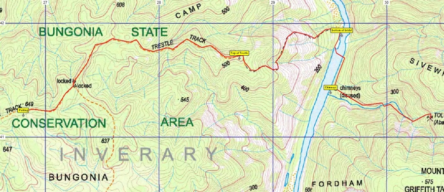
1999 Oct 23 - Trestle Track, Tolwong Mines. Track data generated with OziExplorer on 1:25000 Caoura map from Spatial Services, Bathurst, NSW
23/10/99 Trestle Track, Tolwong Mines. Bungonia State Recreation Area DATE Saturday 23/10/99 and Sunday 24/10/99 WALK Tolwong Chimneys, Shoalhaven River LOCATION Bungonia State Recreation Park MAP Caoura 8928-111-N MAP REFS Parking Area GR 267410, Top of Bridal Trail GR 286415, Bottom of Bridal Trail GR 295417, Chimneys GR 294412, (Editor's note: These grid references are in AGD66 which gives an error of about 200m in current maps.) START Carpark Trestle Track, Bungonia State Recreation Area LENGTH - 10 km TIME Approx. 1.40 hours out Return journey was 1.40 hours GRADE Moderate to top of Bridal Trail, Steep down Bridal Trail, flat along river Steep up to mines COUNTRY Dry Sclerophyll forest on top and down ridge, river flats with she oaks. TERRAIN Step ridges into Shoalhaven gorge. ATTENDANCE 3 LEADER TJD ATTENDEES TJD, Sam Benadetti, Martyn Mordy
WALK DETAILS This walk was organised as part of the Southern Highlands Bushwalkers walk programme. Of the original six who indicated their attendance, only Sam, Martyn and I attended. We left Mittagong at 8 am in overcast conditions with the forecast of rain developing. We met Martyn at Marulan and left his car at the Ranger station.
This area is officially called the Trestle Track. The walk down to the bottom took about an hour (add 40 minutes from the carpark ). The river was obviously running higher than previous visits, and when we got close could see that it was brown - more like the colour of tea than a silty brown.
We planned to camp upstream of the track as this would be central to our planned activities of investigation the ruins and the mines, and walking to the Block Up. After establishing camp and having lunch, we walked across the river to the chimneys; the river was running stronger, and about 6 inches deeper than the last visit, but no deeper than knee deep.
The chimneys were investigated in a different light from the last visit. I had obtained a copy of a Thesis on the history of the smelting activities from the Senior Ranger at Bungonia SRA, Brian Richardson. In this document, amongst another things, is a plan of the site with indications of the activities carried out on them. Martyn had not been to the site previously so we walked around using the plan as our guide and identified most of the areas marked. Many sites are just a flat area - all that remains 85 years after the operation ceased.
My main objective was to find and explore the mines. The track to the mines starts near the top chimney and heads east on the northern side of the gully. The information in the Thesis shows the mines at elevations between 300 and 700 feet. This is obviously wrong as the location is at the head of the gully, approximately 500 metres ( approx 1500 feet ) above sea level. The layout of the mines as described is correct. It took approximately 45 minutes to climb to the location of the mines, with several side tracks being taken as the path becomes indistinct in places. The clue that the mines are close is a very defined side gully which shows several areas of turquoise stain from copper ores. The mines were glimpsed from the track, but no obvious track down was seen, so a scramble down the steep slope brought us to the creek bed and the mines. In this area there are 5 mines close to each other.
The mines appear to be in good condition with little evidence of collapse. The top 4 mines are interconnected with mines 1, 2 and 3 having drives and wooden shoots to feed the ore down to mine 4. The condition of the shoots is very good considering the age. All the mines were reasonably dry. Mine 1 (the eastern most mine ) had a Rock Warblers nest and a small bat roosting. The exploration of the mines was minimal as Martyn is not a cave person, and I would not explore by myself.
Above the mines is a waterfall approximately 20 metres tall. At the base a bath shaped and size trough had been gouged out. This was not mentioned in the Thesis, but as a guess it was for personal use rather than industrial use. This is surmised because of the size and the lack of permanent water flow in this creek. Lower down the gully are mines 6, 6a and 6b, but we did not attempt to find them. The walk back was hazardous in places because of the light drizzle, loose shale and narrow path.
We met up with Sam back at the chimneys. Sam had been stuck on a steep slope for about half an hour waiting for us to return and assist him down. In the end he gave up and dug footholds in the slope. While crossing the river we decided to set up our camp fire under the trees about 500 m from the camp site because of the light rain.
This served us for afternoon tea and dinner. From about 1800 the rain became heavier, so by 1930 we all had retired to our tents. From about 2000 the rain became heavier again and continued so all night. I was extremely pleased with my new tent on its first use. It was easy to erect and kept me and all my equipment dry and warm. We guessed that we had had about 50 mm of rain overnight.
The weather had not changed in the morning and appeared to set in, so we made the decision to pack up and return home. This didn't worry me as I had achieved my major objective of locating and visiting the mines. We left the camp site at 0845 in steady rain, and reached the top at 0945. This track was free from running water until the last 100 metres. Another 40 minutes saw us at the carpark. The 4WD track was running with water, but was not slippery. Several peals of thunder were heard coming up the track and this soon after was accompanied by lighting.
I was concerned with getting out in the car as the first section of the road from the carpark is uphill. This was negotiated with no problem. The last kilometre from the National Park to the bitumen road turned out to be the challenge. This is through private property and not very well maintained at the best of times. I knew that the surface would be rutted with some water, but the surprise was that the last 100 meters was a watercourse! We stopped at the start of this section and could see two small islands before a longer section ( approx 50 metres ) to the last gate. Martyn walked and OK'd the first two sections, so Sam drove and waited on the second island while we investigated the next section. I discovered that the road was under at least 12 inches of fast flowing water, which would have made it difficult to drive through the gate safely. An old roadway to the left went up, out of the watercourse and through an old gate which hade been wired shut. We got Sam to drive to this area, and then we took the gate to pieces so that we could drive through.
If we hadn't found this way out we would most likely have had to wait until late afternoon or Monday to pass this watercourse! If we were an hour later we would not have got this far. We reported our safe return to the Ranger and used the toilets to change into dry clothes. Sam then headed straight for BP Marulan for breakfast, it now being 12:00.
Let us know if you want any particular old reports included here.
David's report of a legal direct by-pass route to Round mountain
with Robert
The search for a Dragon. An aircraft lost in the burragorang in April 1943.
This is a war grave of three Australian pilots and two US marines. All searching
in Schedule 1 water catchment areas has now ceased because of change of catchment authority
policy.
Three day Hill Top to Yerranderie walk, see photos page.